


The through line for the western United States so far in the 2026 water year is simple: there’s very little snow. With few exceptions, the mountains of the U.S. West have seen unusually little snow accumulation since October 2025, constituting a widespread snow drought. The lack of mountain snowpack has resource managers on alert going into the warmer months. Meager meltwater can affect hydropower production, agriculture, aquatic ecosystems, and wildland fire risk.
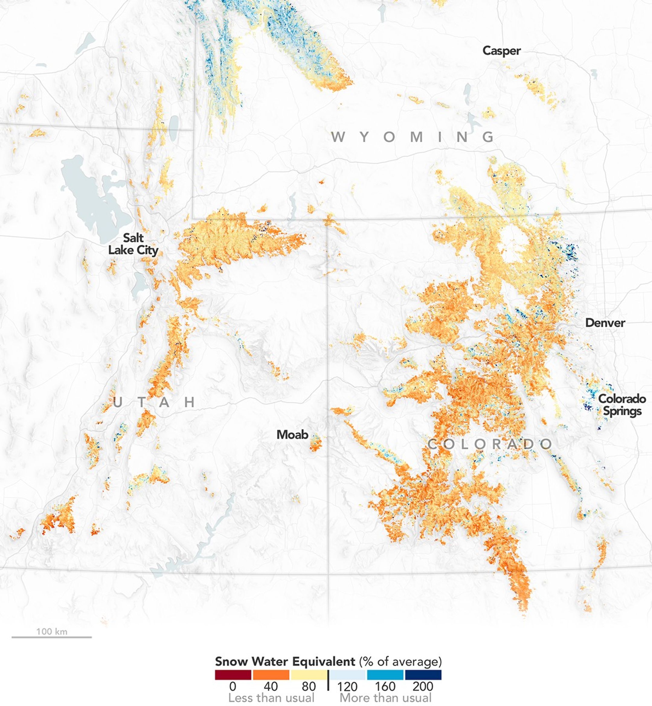
The Upper Colorado Basin was exceptionally dry in spring 2026. This map illustrates the state of its snowpack on March 15, depicting estimates of snow water equivalent as a percentage of the 2001-2025 average. Snow water equivalent (SWE) is a measure of how much water there would be if all the snow in a given area melted at once. SWE peaked for the season around March 15 at below-average values for the time of year in most watersheds. Note that values below 8,000 feet (2,400 meters) in elevation are not shown, as snow at lower elevations often melts quickly and is therefore not representative of overall snowpack health.
To derive these estimates, researchers at the Institute of Arctic and Alpine Research (INSTAAR) combined data from instruments on NASA’s Aqua, Terra, and Landsat satellites, ground-based snow sensors, and a data assimilation model called the Land Information System. The group provides regular, near-real-time snowpack reports to water managers, government agencies, tribes, and other stakeholders in Colorado, California, and other western states throughout each melt season.
The snowpack in spring 2026 was notable not only for its low level but also for its early peak. In the Upper Colorado Basin, SWE peaks on April 6, on average, according to data published by the USDA Natural Resources Conservation Service. In 2026, the peak occurred about four weeks early. Similarly, SWE topped out much earlier than normal across all western states, the National Integrated Drought Information System (NIDIS) reported.
Extreme heat contributed to the shift. In the second half of March, an intense heatwave gripped the southwestern U.S., toppling many high-temperature records. “This heatwave is the big snow story of the year,” said Noah Molotch, mountain hydrologist at INSTAAR and NASA’s Jet Propulsion Laboratory. The Colorado Basin experienced its warmest March on record, according to NIDIS, with temperatures 13.7 degrees Fahrenheit (7.6 degrees Celsius) above normal. Snow water equivalent in the basin plunged through the end of the month.
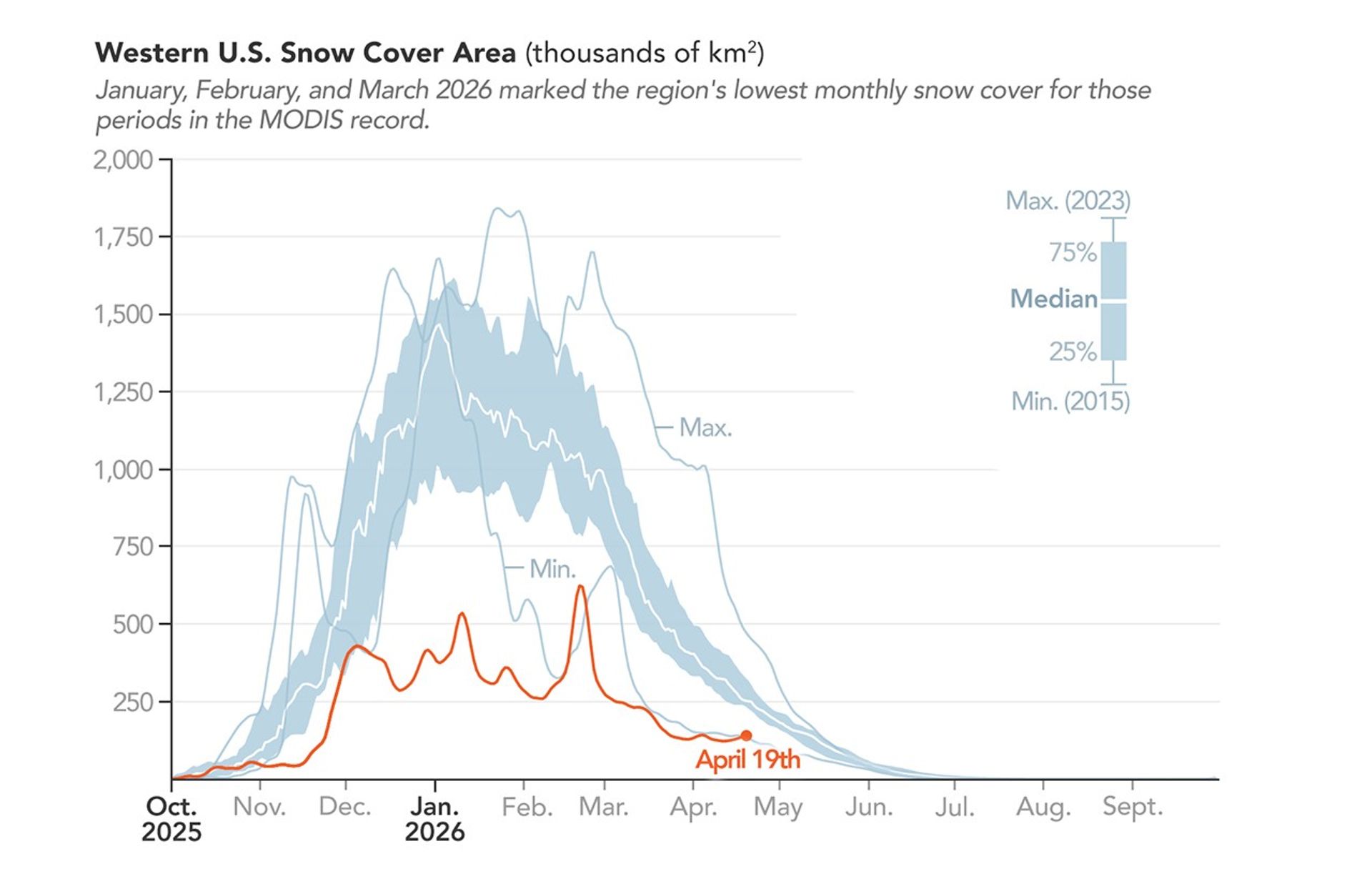
Snow cover across the West (above) dropped noticeably during the late-March heatwave. The melting helped cement March 2026 as the lowest March snow cover in the MODIS (Moderate Resolution Imaging Spectroradiometer) record dating back to 2001. January and February 2026 also had the lowest snow cover for those respective months in the MODIS record, despite widespread snowstorms in the third week of February. The snow cover data is produced by Snow Today, a NASA-funded project of INSTAAR and the National Snow and Ice Data Center.
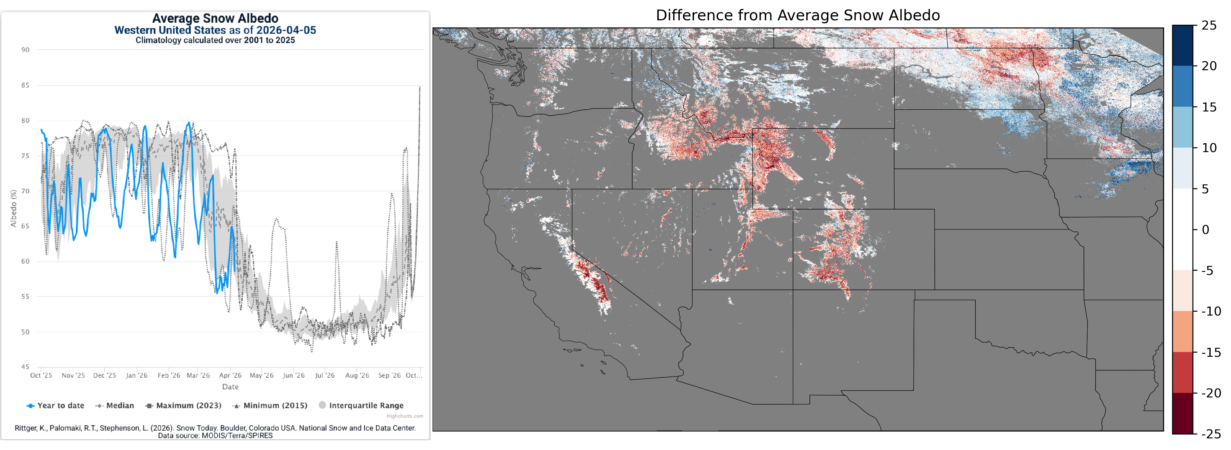
Snow albedo, another metric tracked via satellite, helps tell the story of this winter’s snow drought as well, said Karl Rittger, research associate at INSTAAR and lead scientist at Snow Today. Albedo, or surface brightness, was at average levels for only limited periods during the winter and was otherwise low, Snow Today’s analysis showed, leading to more energy absorption in the snowpack and accelerated melting. Albedo also plunged during the March heatwave.
Storms can “refresh” or brighten the snow, but if they are infrequent, snow grains grow larger and darker, and dust and debris accumulate on the surface. “Storms since the heatwave brought albedo levels back to highs not seen since early March, buffering Colorado’s snowpack temporarily, but not fundamentally changing the outlook,” Rittger said.
The most pronounced effects of the snow drought are expected in areas experiencing consecutive years of drought or snow drought, the NIDIS noted. This includes the Rio Grande and the Pacific Northwest—where a statewide drought was declared in Washington—as well as the Upper Colorado.
Lake Powell, fed by the rivers of the Upper Colorado Basin and impounded by the Glen Canyon Dam in northern Arizona, has dropped to near-historic low levels and was 24 percent full as of April 19, 2026. The Bureau of Reclamation, which manages the dam, projects that the lake could fall below the minimum level needed to produce power by August 2026 “without major intervention,” according to an April 17 news release. The agency said it is considering mitigation strategies, including releasing water from an upstream reservoir and reducing releases from Lake Powell.
NASA Earth Observatory map and chart by Michala Garrison, using data courtesy of L. Lestak, E. Tyrrell, N. Molotch/ Mountain Hydrology Group, University of Colorado, Boulder, and snow cover area data courtesy of K. Rittger/NSIDC Snow Today. Story by Lindsey Doermann.
References & Resources
- Bureau of Reclamation (2026, April 17) Reclamation Acts to Protect Colorado River System During Historic Drought. Accessed April 24, 2026.
- Institute of Arctic and Alpine Research, University of Colorado, Boulder (2026) Mountain Hydrology Group. Accessed April 24, 2026.
- NASA Earth Observatory (2026, January 29) The West Faces Snow Drought. Accessed April 24, 2026.
- National Integrated Drought Information System (2026, April 9) Snow Drought Current Conditions and Impacts in the West. Accessed April 24, 2026.
- National Snow and Ice Data Center (2026, April 8) Playing a broken record. Accessed April 24, 2026.
- The New York Times (2026, March 21) Across the West, Record Heat Is Colliding With a Snow Drought. Accessed April 24, 2026.
- USDA Natural Resources Conservation Service (2026) HUC Based Interactive Plots. Accessed April 24, 2026.
You may also be interested in:
Stay up-to-date with the latest content from NASA as we explore the universe and discover more about our home planet.

Very wet—but very warm—weather in the western U.S. has left many mountainous regions looking at substantial snowpack deficits.

Satellites observed a frozen landscape across much of the country after a massive winter storm.

The country’s northern regions are accustomed to snow, but unrelenting storms have snarled transportation and caused other challenges this winter.


The post Snow Is Scarce in the Upper Colorado Basin appeared first on NASA Science.


