Skip to content
On the Weather

On the Weather

The Natural World in Beauty and Chaos

  • Home
  • About OTW
  • Privacy Policy
  • OTW Affiliates
  • Contact
Weather Blog
  • Home
  • All Regions
  • Weather Blog
  • San Francisco’s Metropolitan Mosaic
  • Weather Blog

San Francisco’s Metropolitan Mosaic

San Francisco’s Metropolitan Mosaic
  1. Science
  2. International Space Station (ISS)
  3. San Francisco’s Metropolitan…
  • Earth
  • Earth Observatory
  • Image of the Day
  • EO Explorer
    • All Topics
    • Atmosphere
    • Land
    • Heat & Radiation
    • Life on Earth
    • Human Dimensions
    • Natural Events
    • Oceans
    • Remote Sensing Technology
    • Snow & Ice
    • Water
    • Collections
    • Global Maps
    • World of Change
    • Articles
    • Earth Matters Blog
    • Blue Marble: Next Generation
    • EO Kids
    • Mission: Biomes
    • About Us
    • Subscribe
    • 🛜 RSS
    • Contact Us
  • Search
 
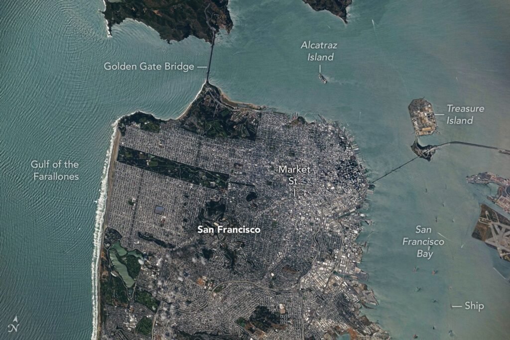
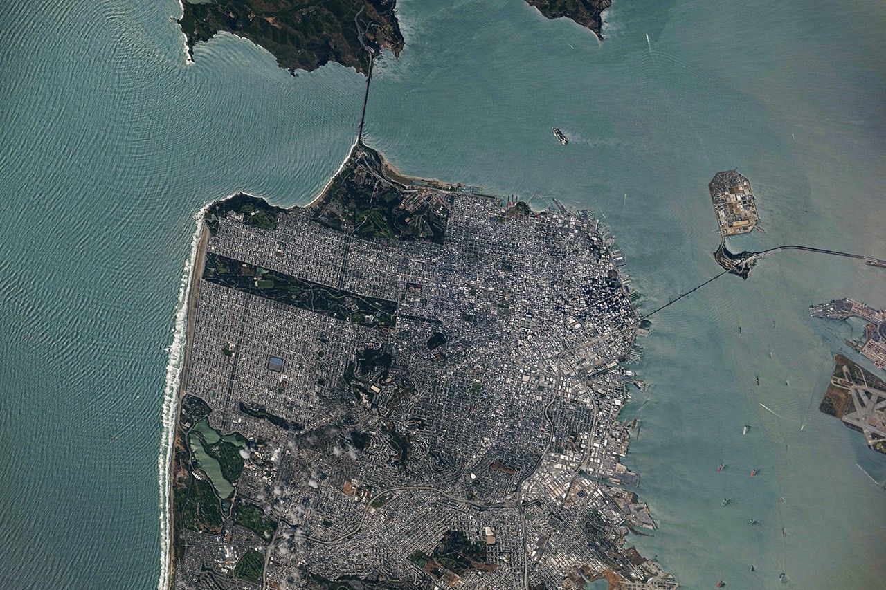
A top-down photo of San Francisco shows dense gray urban infrastructure interspersed with green parks. Waves and ships are visible in the surrounding blue-green water.
May 27, 2026

A period of unsettled weather brought scattered showers and thunderstorms to California’s Bay Area on May 27, 2026. That afternoon, a break in the clouds left downtown San Francisco and nearby communities beneath mostly cloud-free skies, allowing an astronaut aboard the International Space Station to take this photograph.

The image captures two of the region’s iconic bridges. The Golden Gate Bridge connects the northern San Francisco Peninsula with Marin County to the north, while the San Francisco-Oakland Bay Bridge spans the bay toward Oakland to the east.  

Near the center of the image, Golden Gate Park stands out as a long, rectangular strip of green amid the dense urban landscape. Spanning more than 1,000 acres (400 hectares), the park encompasses meadows, gardens, wooded areas, and lakes. Additional green space toward the north around the Golden Gate Bridge is part of a national recreation area. 

The nadir (downward-looking) perspective also provides a clear view of the patchwork of street grids, which were laid out over San Francisco’s hilly terrain as the city grew in successive stages. In the heart of the downtown area, Market Street runs southwest to northeast and serves as a prominent divider between two distinct grid orientations: one aligned with the bay and the other aligned with the street.  

Along the northeastern and eastern waterfront, various structures extend into the bay. Toward the north, these include a historic wharf, seawalls, and piers—most built in the early 1900s, though some date back into the 1800s. The adjacent waters support heavy maritime traffic, including cargo and container ships, cruise vessels, and regional ferries.

Breaking waves are visible along the western coast, including at Ocean Beach, the 3.5-mile stretch of sandy shore adjacent to Golden Gate Park. On May 27, the National Weather Service warned of hazardous conditions at the region’s beaches due to strong northerly winds. Long-period swells from the northwest contributed to the increased risk of rip currents as well as sneaker waves in the days after this image was acquired.

Astronaut photograph ISS074-E-619284 was acquired on May 27, 2026, with a Nikon Z9 digital camera using a focal length of 800 millimeters. It is provided by the ISS Crew Earth Observations Facility and the Earth Science and Remote Sensing Unit at NASA Johnson Space Center. The image was taken by a member of the Expedition 74 crew. The image has been cropped and enhanced to improve contrast, and lens artifacts have been removed. The International Space Station Program supports the laboratory as part of the ISS National Lab to help astronauts take pictures of Earth that will be of the greatest value to scientists and the public, and to make those images freely available on the Internet. Additional images taken by astronauts and cosmonauts can be viewed at the NASA/JSC Gateway to Astronaut Photography of Earth. Story by Kathryn Hansen.
Downloads

A top-down photo of San Francisco shows dense gray urban infrastructure interspersed with green parks. Waves and ships are visible in the surrounding blue-green water.

May 27, 2026

JPEG (12.13 MB)

References & Resources

  • California State Parks, Port of San Francisco Embarcadero Historic District. Accessed June 8, 2026.
  • National Park Service, Golden Gate National Recreation Area. Accessed June 8, 2026.
  • NWS Bay Area via X (2026, May 27) Heading to the beach tomorrow? Accessed June 8, 2026.
  • NWS Bay Area via X (2026, May 27) Radar Update: Showers with brief downpours and some isolated thunderstorms are winding down. Accessed June 8, 2026.
  • NWS Bay Area via X (2026, May 26) The ocean is not your friend today and tomorrow! Accessed June 8, 2026.
  • San Francisco Recreation & Parks, Discover Golden Gate Park. Accessed June 8, 2026.

You may also be interested in:

Stay up-to-date with the latest content from NASA as we explore the universe and discover more about our home planet.
Belts of Green in the Washington Suburbs

3 min read

Along the northeast side of the Capital Beltway in Maryland, green spaces weave through the developed landscape.

Article

Contours of the James Bay Lowlands

3 min read

After the Laurentide Ice Sheet retreated from present-day Hudson Bay, rebounding land has revealed striking nearshore topography.
Article

Great Balls of Fire

4 min read

An astronaut on the International Space Station was surprised to photograph a shower of light streaking through the darkness while…


Article

1


2


3


4

Next
Keep Exploring

Discover More from NASA Earth Science

Subscribe to Earth Observatory Newsletters

Subscribe to the Earth Observatory and get the Earth in your inbox.


Earth Observatory Image of the Day

NASA’s Earth Observatory brings you the Earth, every day, with in-depth stories and stunning imagery.


Explore Earth Science


Earth Science Data

Open access to NASA’s archive of Earth science data

The post San Francisco’s Metropolitan Mosaic appeared first on NASA Science.

​  

About Author

OTW Observer

See author's posts

Post navigation

Previous Rare Gulf Earthquake could be the Region’s Strongest…
Next Met Office verdict on 30C heat this weekend

Related Stories

Where Venezuela’s Earthquakes Shifted the Ground Where Venezuela’s Earthquakes Shifted the Ground
  • Weather Blog

Where Venezuela’s Earthquakes Shifted the Ground

July 10, 2026
Super Typhoon Bavi Super Typhoon Bavi
  • Weather Blog

Super Typhoon Bavi

July 9, 2026
Cottonwood Fire Chars Utah Cottonwood Fire Chars Utah
  • Weather Blog

Cottonwood Fire Chars Utah

July 8, 2026

Recent Posts

Recent Comments

No comments to show.

Archives

  • July 2026
  • June 2026
  • May 2026
  • April 2026
  • March 2026
  • February 2026
  • January 2026
  • December 2025
  • November 2025
  • October 2025
  • September 2025
  • August 2025
  • July 2025
  • June 2025
  • May 2025
  • April 2025
  • March 2025
  • February 2025
  • January 2025
  • December 2024
  • November 2024
  • October 2024
  • September 2024
  • August 2024
  • July 2024
  • June 2024
  • May 2024
  • April 2024
  • March 2024
  • February 2024
  • January 2024
  • December 2023
  • November 2023
  • October 2023
  • September 2023
  • August 2023
  • July 2023
  • June 2023
  • May 2023
  • April 2023
  • March 2023
  • February 2023
  • January 2023
  • December 2022
  • November 2022
  • August 2021
  • February 2021
  • June 2020
  • December 2018

Categories

  • All Regions
  • Americas
  • Asia-Pacific
  • Atlantic
  • Caribbean
  • Europe
  • Oceania
  • South China Sea
  • Weather Blog

Weather Media Roundup

Where Venezuela’s Earthquakes Shifted the Ground Where Venezuela’s Earthquakes Shifted the Ground
  • Weather Blog

Where Venezuela’s Earthquakes Shifted the Ground

July 10, 2026
Worst in Years… Worst in Years...
  • Caribbean

Worst in Years…

July 9, 2026
UK heatwave to last longer than expected as Met Office reveals when London will cool down slightly UK heatwave to last longer than expected as Met Office reveals when London will cool down slightly
  • All Regions
  • Europe

UK heatwave to last longer than expected as Met Office reveals when London will cool down slightly

July 9, 2026
Super Typhoon Bavi Super Typhoon Bavi
  • Weather Blog

Super Typhoon Bavi

July 9, 2026

OTW Hosting by Hostinger

Disclosure statement: Links to affiliate products are listed here. Ontheweather.com maybe compensated by displaying and promoting products seen here. Some of the products maybe of interest to you. Learn more about ontheweather.com privacy policy page.

Copyright © All rights reserved. OTW 2024 | DarkNews by AF themes.