


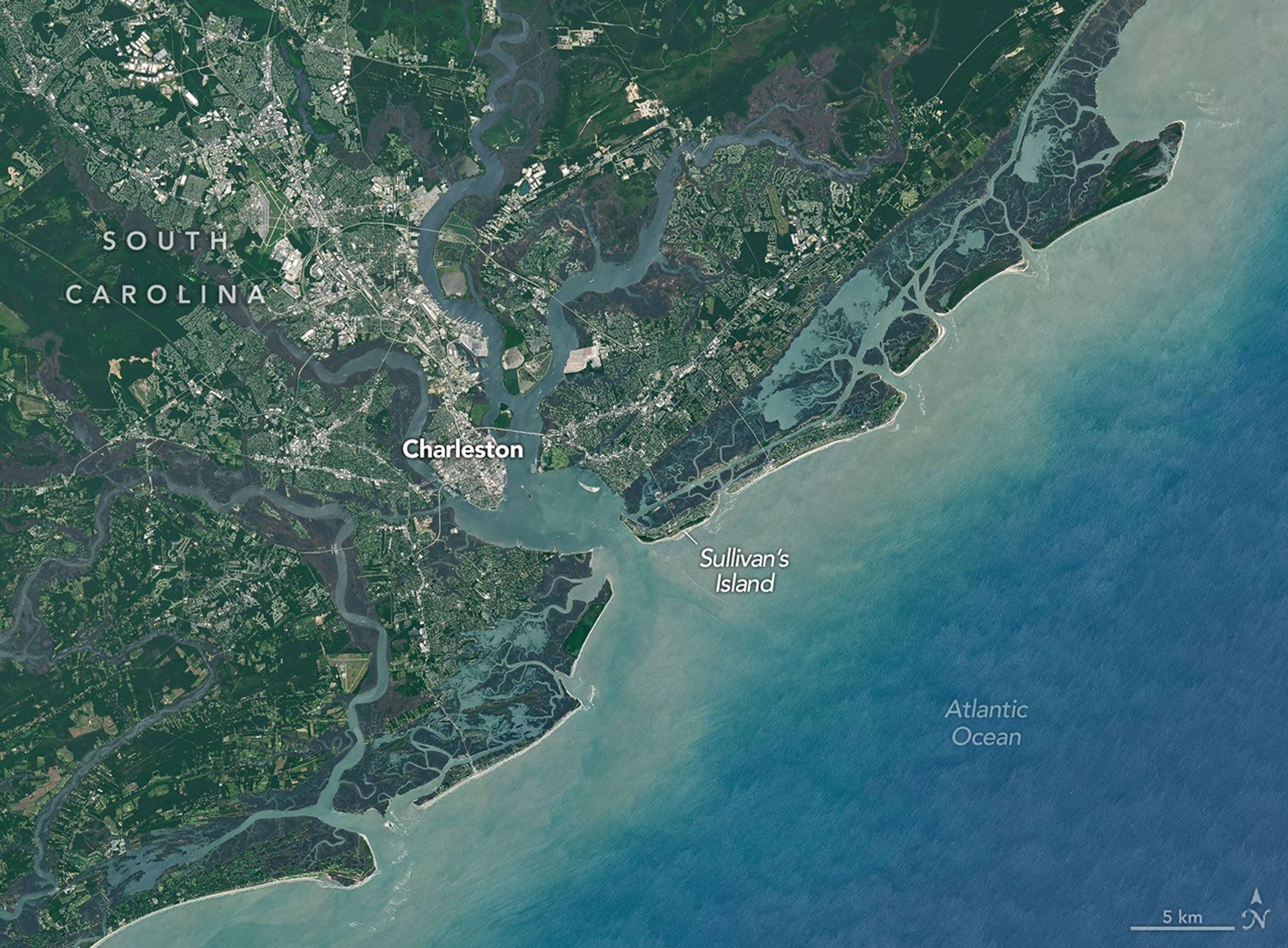
As Thomas Jefferson and the Committee of Five presented their first draft of the Declaration of Independence in Philadelphia on June 28, 1776, several British warships and thousands of troops were massing around Sullivan’s Island in South Carolina.
The pitched battle for the sandy barrier island at the mouth of Charleston Harbor that played out over the course of that June day was one of the most significant in the early stages of the Revolutionary War. By nightfall, largely untested colonial troops had decisively defeated the British, an outcome that helped save Charleston from occupation and buoyed American spirits at a critical stage of the war.
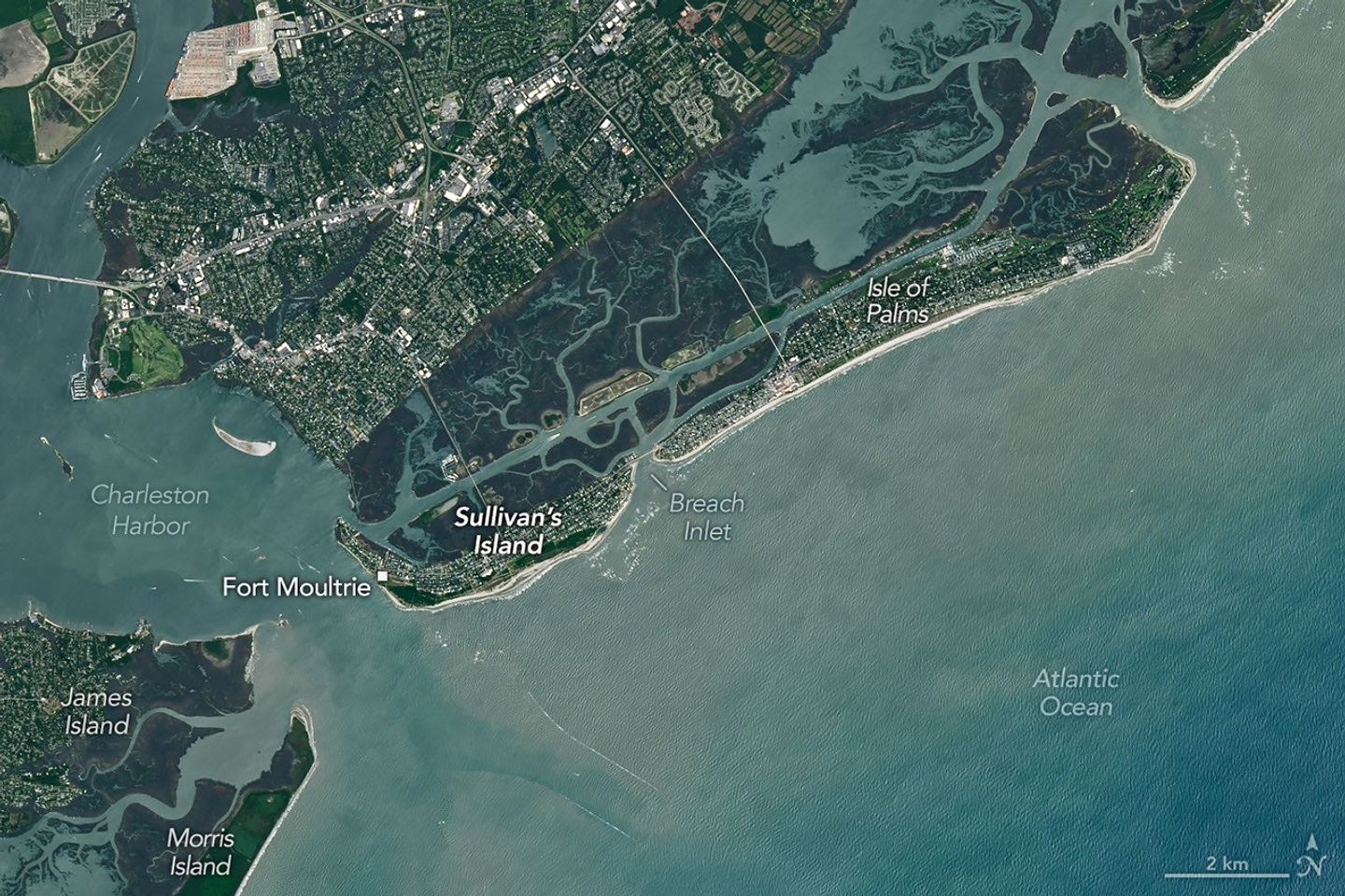
The Landsat 8 satellite captured this image of the island on June 3, 2026. Two hundred fifty years earlier, the sandy beaches, salt marshes, and general shape of the island would have looked similar, though with less evidence of roads or other signs of human development.
There certainly would have been some signs of human activity on the island, however. Quite noticeable would have been Fort Sullivan, a large square structure built from palmetto logs on the southern tip of the island, near the entrance to the harbor. Though one side of the fort, assembled largely by enslaved people, was still unfinished at the time of the battle, the other sides had 16-foot-wide walls packed with sand and containing planked gun platforms that mounted 31 cannons.
Historical maps show at least one road extending from the southern to northern tip of Sullivan’s Island, where hundreds of colonial soldiers were also encamped to protect Breach Inlet from a force of roughly 3,000 British troops massing on nearby Long Island (now Isle of Palms). When the battle began, historians estimate that there were roughly 800 colonial troops, including dozens of Catawba warriors, defending the northeastern part of Sullivan’s Island, embedded within earthen defenses and manning two artillery pieces.
When the British attack came on the morning of June 28, 1776, both military tactics and geography played critical roles in determining the outcome. Having been told the water at the inlet was less than 18 inches (46 centimeters) deep at low tide, the British commander had planned to have his forces walk across Breach Inlet on foot. But he was forced to pivot to a more dangerous amphibious assault using flatboats when he realized the shallowest part of the break was at least 7 feet (2 meters) deep at low tide. Traveling by flatboat limited the number of British troops who could cross the channel at once, making it easier for colonial defenders to repel them during fierce skirmishing throughout the day.
On the other side of the island, British warships had dropped anchor near Fort Sullivan and begun launching thousands of cannonballs and exploding shells at the fort. However, the natural durability and pliability of the palmetto wood absorbed incoming fire “like sponges,” Colonel William Moultrie, the fort’s commanding officer, later noted in his memoirs.
Most incoming shells that fell within the fort’s walls were neutralized. There was a marshy “morass” in the center of the fort, Moultrie wrote, that “swallowed” up incoming fire “instantly.” Shells that made it over the walls and “fell in the sand, in and about the fort, were immediately buried, so that few of them burst amongst us,” he wrote.
With their limited powder, the colonists focused their fire on the ship carrying the British commander, Sir Peter Parker, severely damaging it and ultimately killing 40 people on board. By the evening, exhausted from the 10-hour battle and making little progress, the British forces retreated.
“We never had such a drubbing in our lives,” one Royal Navy sailor wrote. After the battle, the fort became known as Fort Moultrie, and the palmetto tree began appearing on the state seal in what would prove to be an enduring symbol of colonial pride and resistance. Six days after the battle, the Declaration of Independence was adopted in Philadelphia.
NASA Earth Observatory images by Michala Garrison, using Landsat data from the U.S. Geological Survey. Story by Adam Voiland.


References & Resources
- American Battlefield Trust, Sullivan’s Island. Accessed June 25, 2026.
- George Washington Presidential Library at Mount Vernon, Battle of Sullivan’s Island. Accessed June 25, 2026.
- The Island Packet (2024, April 20) Know why SC is nicknamed The Palmetto State? There’s more history to it than you may think. Accessed June 25, 2026.
- Journal of the American Revolution (2023, May 11) Danger at the Breach. Accessed June 25, 2026.
- Moultrie, W. (1802) Memoirs of the American Revolution. Accessed June 25, 2026.
- NASA Earth Observatory (2018, June 10) History and Seaports in Charleston. Accessed June 25, 2026.
- National Museum of the United States Army, The Royal Navy Assault on Sullivan’s Island. Accessed June 25, 2026.
- National Park Service Fort Moultrie. Accessed June 25, 2026.
- National Park Service (1968, June 30) The Battle of Sullivan’s Island. Accessed June 25, 2026.
- Princeton University Drafting the Declaration of Independence. Accessed June 25, 2026.
- Royal Collection Trust (1776) Map of Fort Sullivan and Charlestown, 1776 (Fort Moultrie, Sullivan’s Island, South Carolina, USA). Accessed June 25, 2026.
You may also be interested in:
Stay up-to-date with the latest content from NASA as we explore the universe and discover more about our home planet.

Beaver Island is one in a string of verdant and scenic jewels in a northern Lake Michigan archipelago.

Icy, isolated Peter I Island stirred up a show in the atmosphere off the West Antarctic coast.

The blaze spread across the southern side of the second-largest island in California’s Channel Islands National Park.


The post The Battle for Sullivan’s Island appeared first on NASA Science.


