
Alpine glaciers, wild coastlines, temperate rainforests, and deep river valleys coexist on the Olympic Peninsula in the northwest corner of Washington state. Surrounded by blue waters, peaceful islands, and bustling population centers, its rugged interior remains a relatively remote bastion of wilderness.
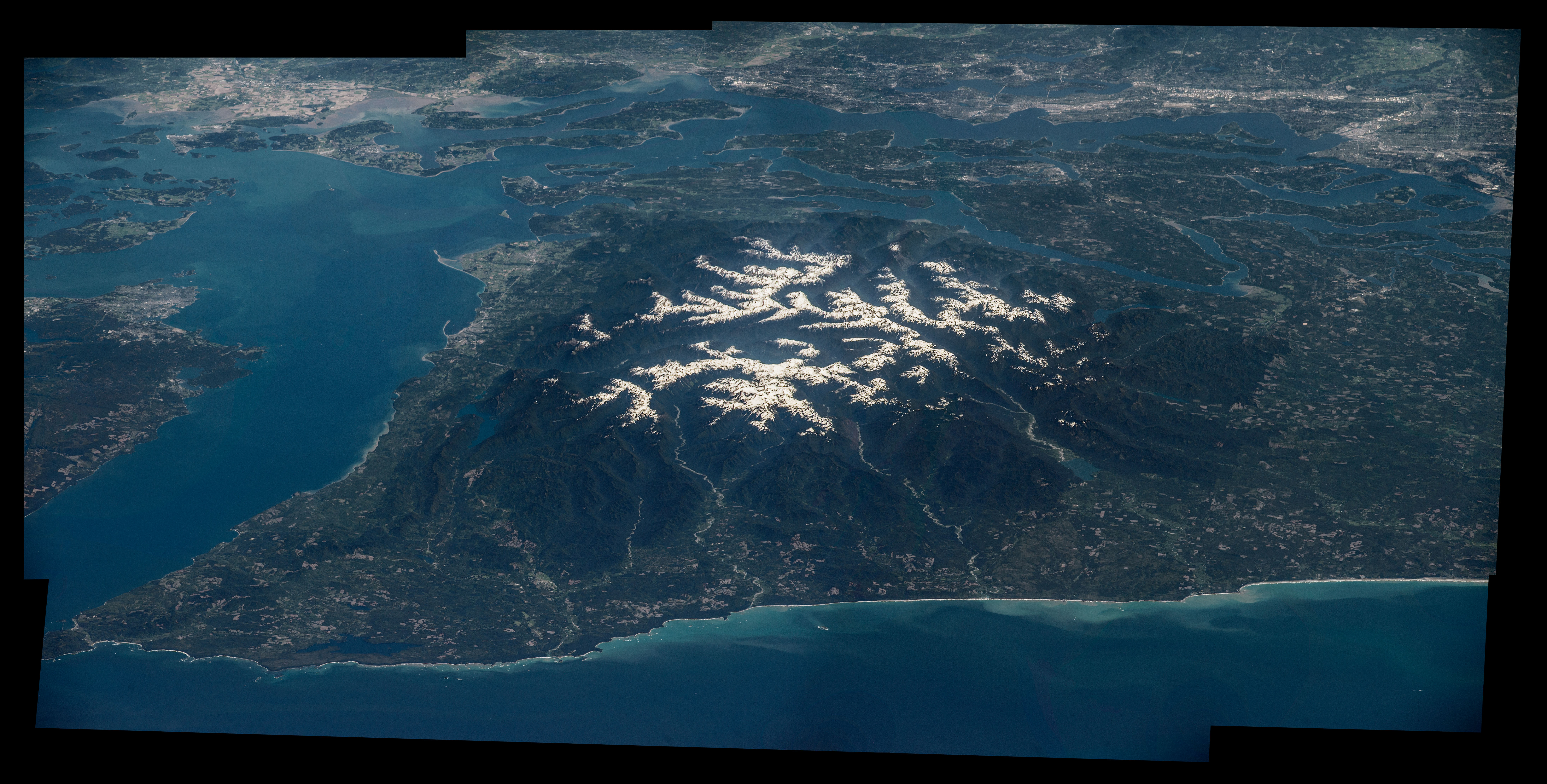
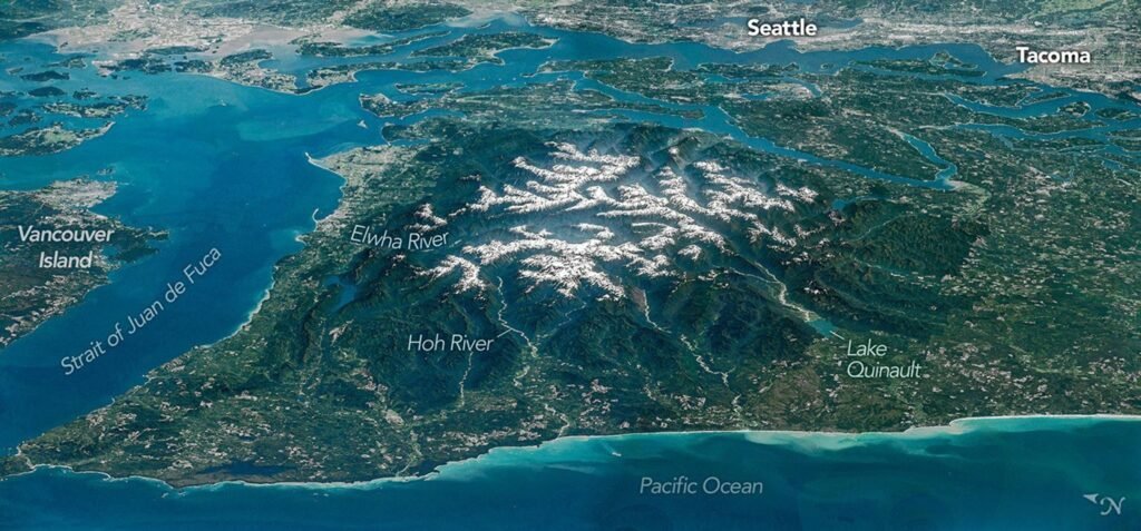
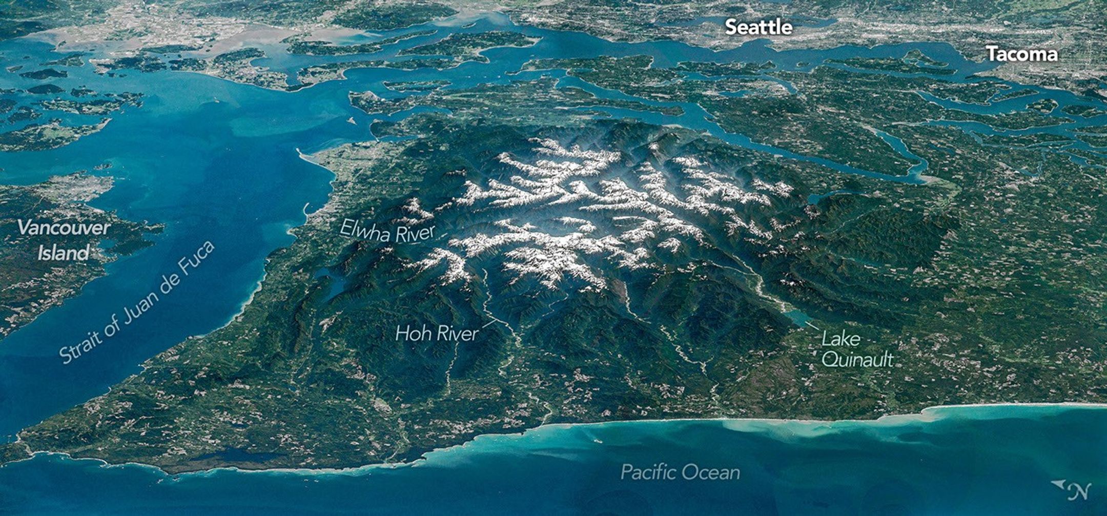
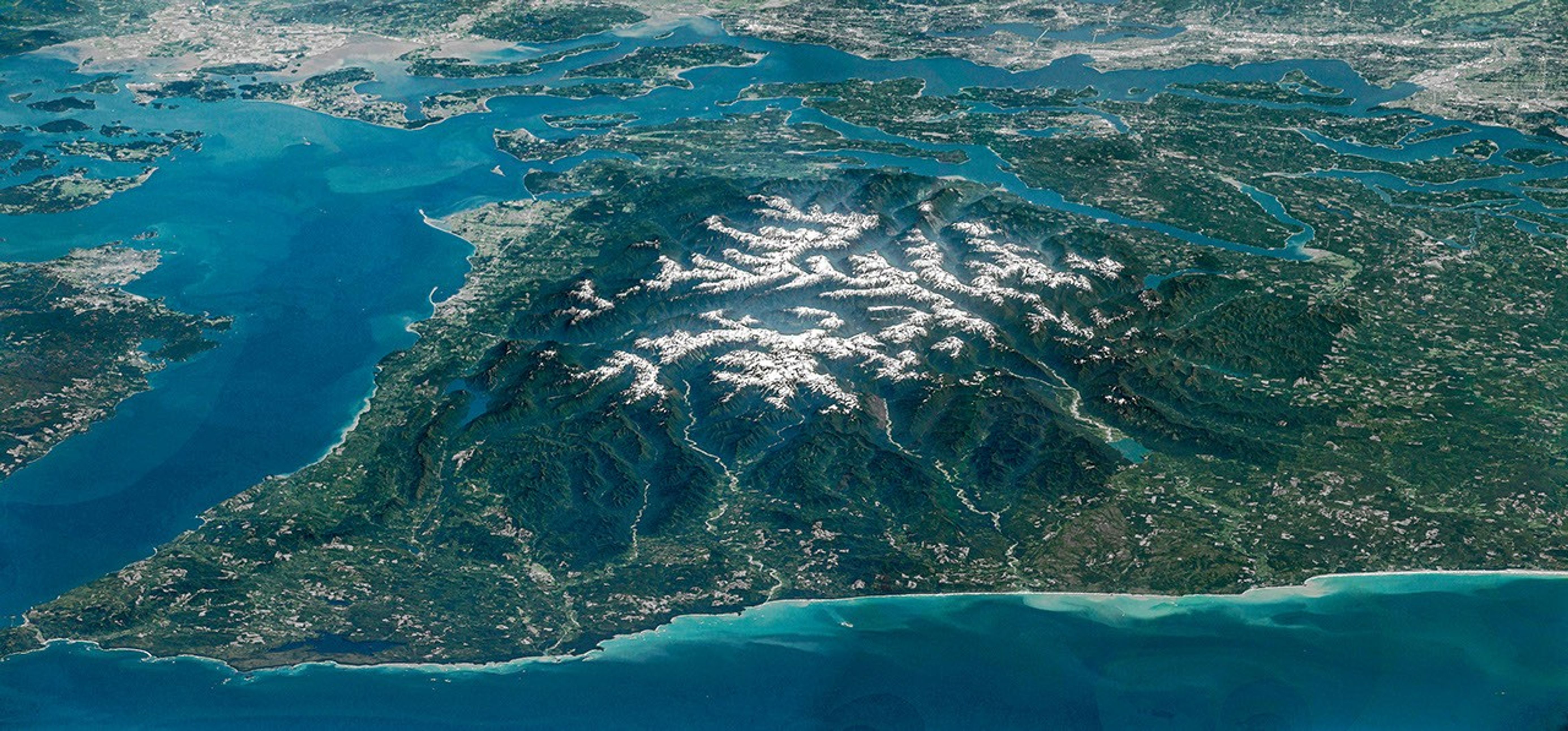
The Olympic Mountains’ imposing terrain comes into focus in this oblique view of the region, captured by an astronaut aboard the International Space Station. The image is a composite, made of several sequential, overlapping photos fused together into a panorama. Olympic National Park encompasses the peninsula’s mountainous core, along with some stretches of the Pacific coastline. Much of the remaining area is either national forest, state-owned land, or tribal territory.
The rock making up the mountains mostly originated beneath the surface of the ocean. From about 55 to 15 million years ago, layers of basalt from undersea eruptions and sand and mud transported seaward by rivers accumulated on the ocean bottom. This material was scraped off the Juan de Fuca plate as it subducted beneath the North American plate, with rock layers crumpling and rising up to 8,000 feet (2,440 meters) above sea level.
Tectonic forces continue to push the mountains skyward, but the countervailing force of erosion in this rainy, snowy corner of the country effectively cancels out the uplift. Snow at higher elevations feeds glaciers that carve out underlying rock. Glaciers in the Olympics are retreating and thinning, however, and their numbers are declining. One study tallied 255 glaciers and perennial snowfields in the range in 2015 and found that 35 glaciers and 16 perennial snowfields had disappeared in the preceding 35 years.
Other erosion is evidenced by the deep valleys radiating out from the snowy peaks. The Hoh, Queets, and Quinault rivers, draining west into the Pacific Ocean (bottom of the frame), are prominent in this view. These verdant valleys are known for their temperate rainforests, and the ancient forest in the Hoh River valley was once considered among the most naturally quiet places in the U.S., uninterrupted by human-caused noise.
Flowing to the north, the Elwha River has a rich natural and human history, including some of the earliest Euro-American exploration of the Olympics. Sponsored by a Seattle newspaper, an expedition from December 1889 to May 1890 crossed the mountain range from north to south, traveling up the Elwha valley and down the Quinault. The party spent several months in the Elwha Valley, their progress hindered by an unusually harsh and snowy winter.
In the early 1900s, entrepreneurs saw economic opportunity in the valley. Two dams constructed on the river produced power for local industry. But the structures came with costs, such as blocking the migration of once-abundant trout and salmon to their spawning grounds. In 2011 and 2014, the dams were removed in what was then the largest such project in the U.S., and the process of restoring fish populations, seeding native plant communities, and replenishing sediment along the riverbanks commenced.
The mouth of the Elwha forms a delta in the Strait of Juan de Fuca, the waterway bordering the peninsula to the north. The U.S.-Canada border runs through the middle of this 11- to 17-mile-wide (18- to 27-kilometer-wide) channel, with Vancouver Island in British Columbia lying to the north. The strait connects the Pacific Ocean with the Strait of Georgia and Puget Sound. Ship traffic uses the strait to access important West Coast ports, including Seattle and Tacoma, visible along the top-right edge of the image.
Astronaut photographs ISS047-E-104138 through ISS047-E-104144 were acquired on May 6, 2016, with a Nikon D4 digital camera using a focal length of 400 millimeters. They are provided by the ISS Crew Earth Observations Facility and the Earth Science and Remote Sensing Unit at NASA Johnson Space Center. The images were taken by a member of the Expedition 47 crew. The images have been cropped and enhanced to improve contrast, and lens artifacts have been removed. The International Space Station Program supports the laboratory as part of the ISS National Lab to help astronauts take pictures of Earth that will be of the greatest value to scientists and the public, and to make those images freely available on the Internet. Additional images taken by astronauts and cosmonauts can be viewed at the NASA/JSC Gateway to Astronaut Photography of Earth. Story by Lindsey Doermann.
References & Resources
- Fountain, A. G., et al. (2022) Glaciers of the Olympic Mountains, Washington—The past and future 100 years. Journal of Geophysical Research: Earth Surface, 127(4), e2022JF006670.
- NASA Earth Observatory (2016, February 14) Olympic National Park. Accessed July 22, 2026.
- NASA Earth Observatory (2012, August 25) Restoration of the Elwha River. Accessed July 22, 2026.
- National Park Service (2026, July 7) Olympic National Park. Accessed July 22, 2026.
- Washington State Department of Natural Resources, Olympic Mountains. Accessed July 22, 2026.
You may also be interested in:
Stay up-to-date with the latest content from NASA as we explore the universe and discover more about our home planet.
Along the northeast side of the Capital Beltway in Maryland, green spaces weave through the developed landscape.
The colonial communities of “America’s historic triangle” played defining roles in the road to American independence.
An astronaut on the International Space Station was surprised to photograph a shower of light streaking through the darkness while…




The post Olympic Mountain Glory appeared first on NASA Science.
About Author