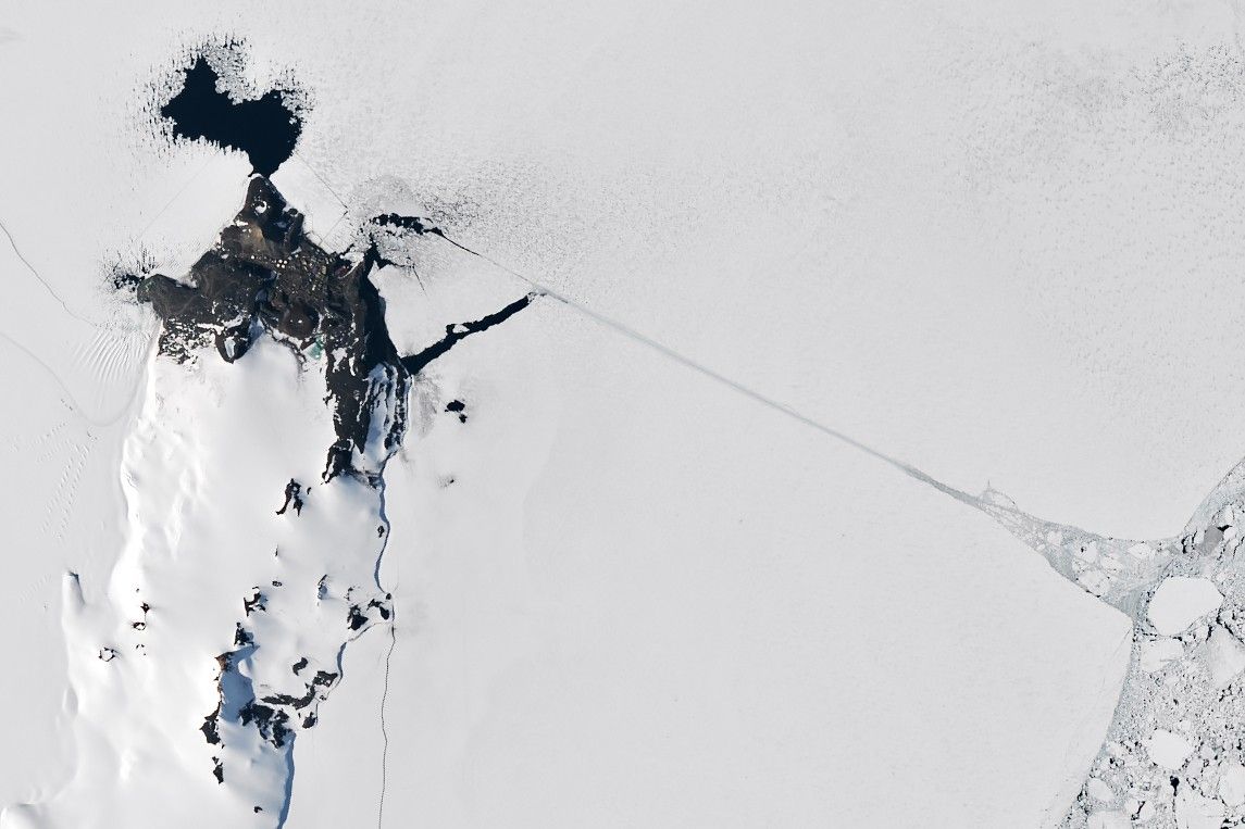
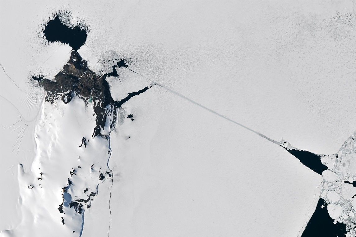
Skip to content
On the Weather

On the Weather

The Natural World in Beauty and Chaos

  • Home
  • About OTW
  • Privacy Policy
  • OTW Affiliates
  • Contact
Weather Blog
  • Home
  • All Regions
  • Weather Blog
  • Cracking Antarctic Sea Ice
  • Weather Blog

Cracking Antarctic Sea Ice

Cracking Antarctic Sea Ice
  1. Science
  2. Earth Observatory
  3. Cracking Antarctic Sea Ice
  • Earth
  • Earth Observatory
  • Image of the Day
  • EO Explorer
    • All Topics
    • Atmosphere
    • Land
    • Heat & Radiation
    • Life on Earth
    • Human Dimensions
    • Natural Events
    • Oceans
    • Remote Sensing Technology
    • Snow & Ice
    • Water
    • Collections
    • Global Maps
    • World of Change
    • Articles
    • Notes from the Field Blog
    • Earth Matters Blog
    • Blue Marble: Next Generation
    • EO Kids
    • Mission: Biomes
    • About Us
    • Subscribe
    • 🛜 RSS
    • Contact Us
  • Search


January 19
January 20

A satellite image shows sea ice along Antarctica’s Ross Island near McMurdo Station. Buildings and fuel tanks are visible on land. The start of a straight channel, cut by an icebreaker through the sea ice, is visible toward the right, originating from small area of dark open water.
NASA Earth Observatory

A satellite image of the same area shows a completed channel cut by an icebreaker through the sea ice. The ship channel stretches about 10 kilometers from open water on the right to McMurdo Station on the left.
NASA Earth Observatory

A satellite image shows sea ice along Antarctica’s Ross Island near McMurdo Station. Buildings and fuel tanks are visible on land. The start of a straight channel, cut by an icebreaker through the sea ice, is visible toward the right, originating from small area of dark open water.
NASA Earth Observatory
A satellite image of the same area shows a completed channel cut by an icebreaker through the sea ice. The ship channel stretches about 10 kilometers from open water on the right to McMurdo Station on the left.
NASA Earth Observatory

January 19

January 20


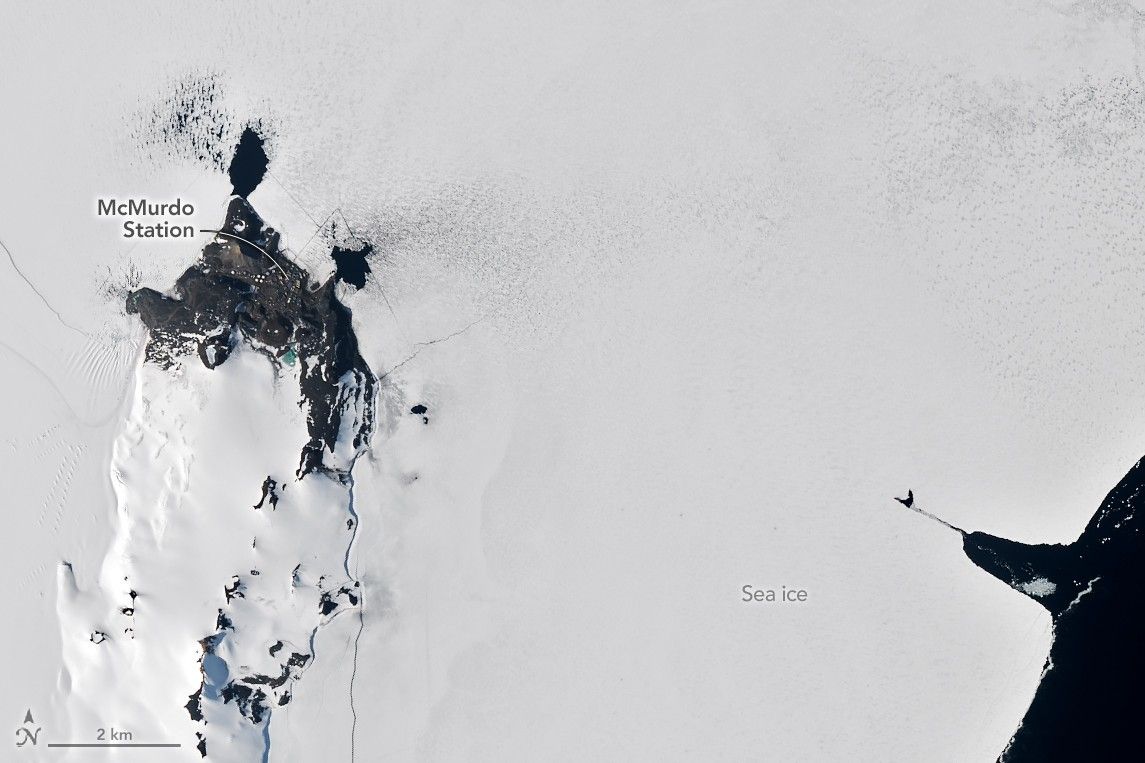
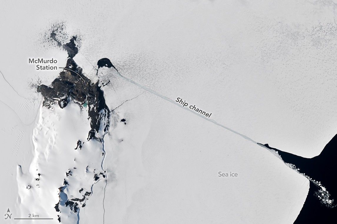
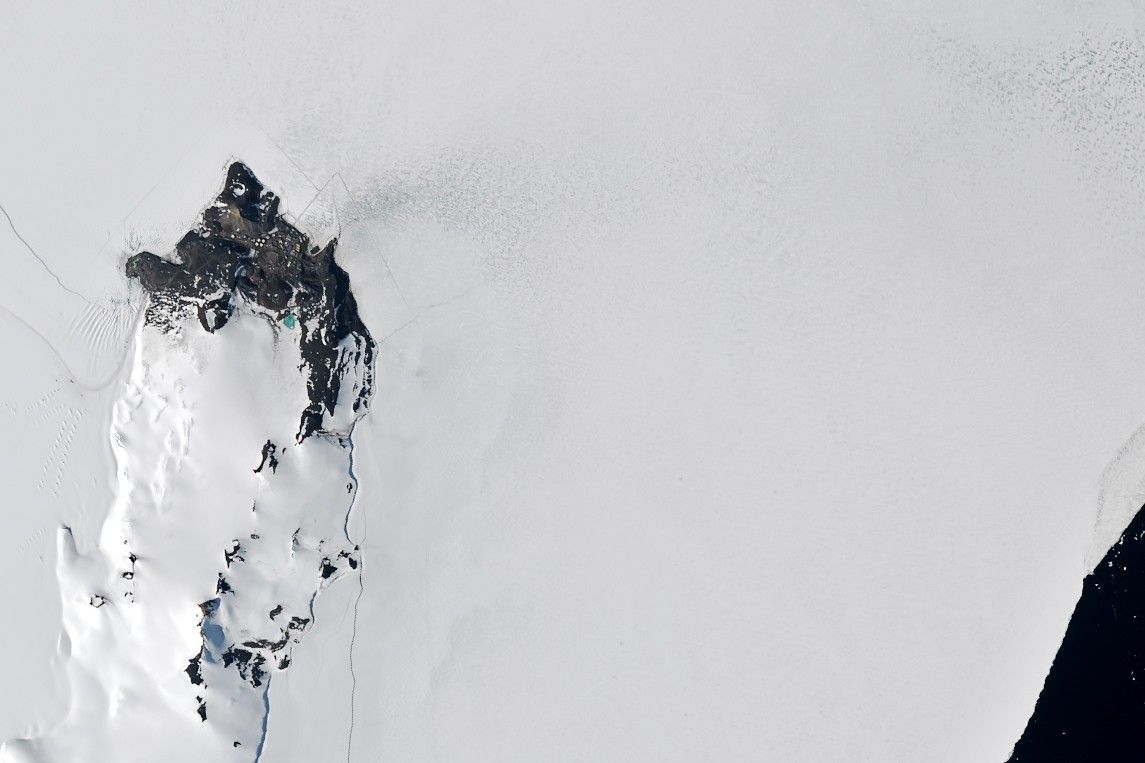
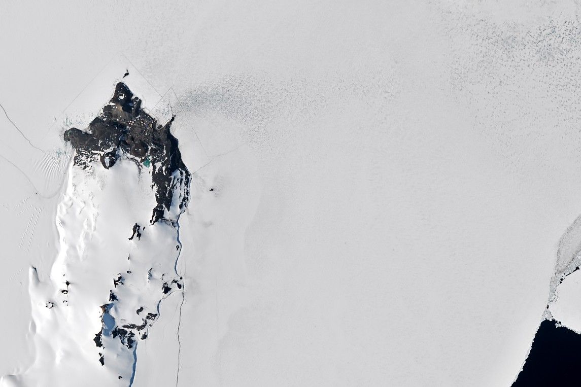
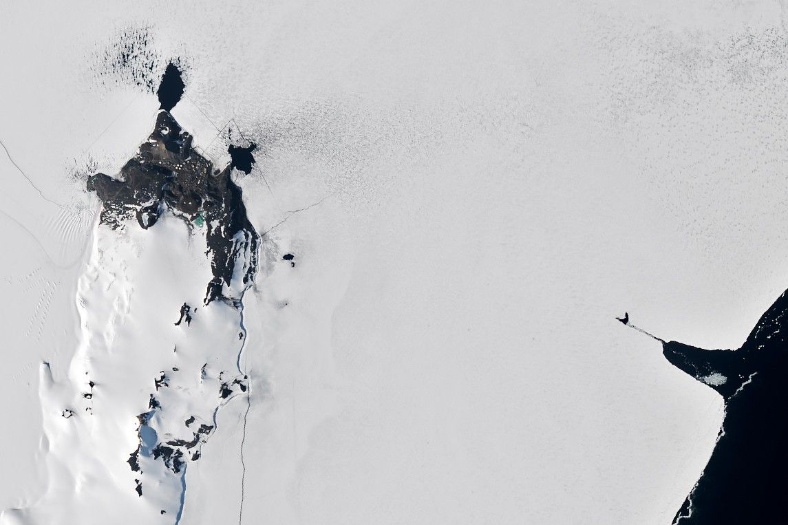
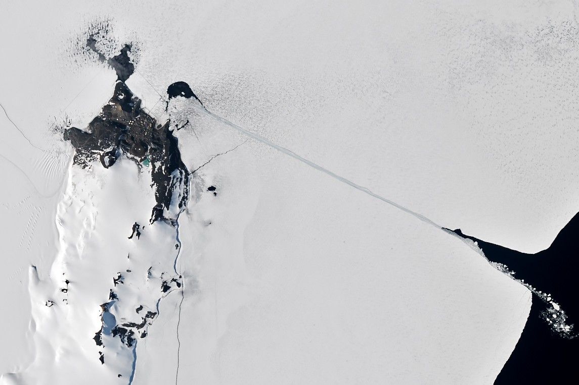
‘Tis the season for long and ruler-straight cracks in McMurdo Sound’s sea ice. Though natural breaks in sea ice are called leads, the better term for the human-made fracture seen in these satellite images is a ship channel.

In the austral summer, usually in January, an icebreaker rams a path through the fast ice—a type of sea ice that is anchored to the shore—that often covers McMurdo Sound. This annual effort allows cargo ships to reach McMurdo Station, a research base operated by the United States Antarctic Program. The U.S. Coast Guard Cutter Polar Star completed the task in January 2026, arriving after breaking a path through several miles of ice between the Ross Sea and an ice pier at McMurdo. Most of the channel was cut between January 19 and 20.  

Seven satellite images captured in January 2026 show a stepwise lengthening of a ship channel in sea ice flanking the coast of Ross Island. The channel spans diagonally across the image, from an area of dark open water on the bottom-right to a research base on the top-left.
January 2 – January 27, 2026

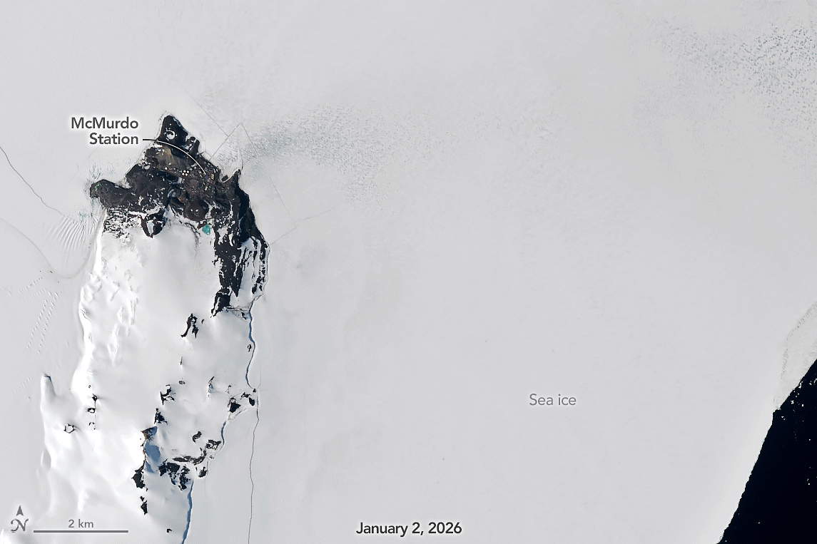
The animation above, made of images captured by the OLI (Operational Land Imager) on Landsat 8 and 9, offers satellite views of the icebreaker’s work. Images were captured on January 2, 7, 19, 20, 23, 25, and 27. The nearly 120-meter (400-foot) vessel weighs 13,500 tons and has thick steel-plated hulls. With 75,000 shaft horsepower, it’s the world’s most powerful non-nuclear icebreaker.

The ship sometimes conducts search-and-rescue missions as well. On January 17, the day marking its 50th year of service, the Polar Star responded to a call from an Australian cruise ship in the Ross Sea hampered by thick, pack ice—a type of sea ice unattached to the shoreline that drifts. After making two close passes to break up the ice and clear a path, the Polar Star escorted the cruise ship 4 nautical miles (7 kilometers) to open water in the Ross Sea, according to the U.S. Coast Guard.

A reference map of Antarctica shows the continent in white surrounded by light blue ocean. Labels identify the Weddell Sea, Amundsen Sea, Ross Ice Shelf, Ronne Ice Shelf, West Antarctica, and the Antarctic Peninsula. A small boxed area near the Ross Ice Shelf marks the “Area of Landsat images." This boxed area is centered on sea ice in McMurdo Sound near McMurdo Station.

Established in 1955, McMurdo Station is the southernmost point on Earth accessible by ship. With a population that swells to 1,200 in the summer, it is the largest research station in Antarctica, hosting a harbor, two airfields, and a helicopter pad. Though once powered by a portable nuclear reactor known as “Nukey Poo,” the base now runs on energy from diesel electric generators and a wind farm on Crater Hill.

With the ship passage open, McMurdo Station is slated to receive two large deliveries this summer. The Stena Polaris, a tanker, arrived on January 20 with 5 million gallons of diesel fuel. Plantijngracht, a cargo ship, will arrive later with food, supplies, and parts of a new floating pier that will replace the traditional ice pier that military engineers have constructed each winter to give ships somewhere to unload cargo.

The U.S. National Science Foundation manages McMurdo Station and much of the science conducted there. NASA has also been involved in several projects at the base over the years. For instance, NASA’s McMurdo Ground Station, a Near Space Network facility, is used to download data from polar-orbiting satellites such as Landsat 9 and SMAP. The agency also flew its Operation Ice Bridge airborne campaign from McMurdo in 2013 and regularly launches research balloons from the station as part of its scientific ballooning program.

The Polar Star typically remains at McMurdo through March to keep the ship passage clear and returns to its home port of Seattle in April.

NASA Earth Observatory images by Michala Garrison, using Landsat data from the U.S. Geological Survey. Story by Adam Voiland.

Downloads

A satellite image shows sea ice along Antarctica’s Ross Island near McMurdo Station. Buildings and fuel tanks are visible on land. The start of a straight channel, cut by an icebreaker through the sea ice, is visible toward the right, originating from small area of dark open water.

January 2, 2026

JPEG (347.10 KB)

A satellite image shows sea ice along Antarctica’s Ross Island near McMurdo Station. Buildings and fuel tanks are visible on land. The start of a straight channel, cut by an icebreaker through the sea ice, is visible toward the right, originating from small area of dark open water.

January 7, 2026

JPEG (371.12 KB)

A satellite image shows sea ice along Antarctica’s Ross Island near McMurdo Station. Buildings and fuel tanks are visible on land. The start of a straight channel, cut by an icebreaker through the sea ice, is visible toward the right, originating from small area of dark open water.

January 19, 2026

JPEG (396.28 KB)

A satellite image of the same area shows a completed channel cut by an icebreaker through the sea ice. The ship channel stretches about 10 kilometers from open water on the right to McMurdo Station on the left.

January 20, 2026

JPEG (406.54 KB)

A satellite image of the same area shows a completed channel cut by an icebreaker through the sea ice. The ship channel stretches about 10 kilometers from open water on the right to McMurdo Station on the left.

January 23, 2026

JPEG (390.37 KB)

A satellite image of the same area shows a completed channel cut by an icebreaker through the sea ice. The ship channel stretches about 10 kilometers from open water on the right to McMurdo Station on the left.

January 25, 2026

JPEG (426.85 KB)

References & Resources

  • Atlas Obscura (2024, March 20) McMurdo Ice Pier. Accessed February 2, 2026.
  • Cruise Industry News (2026, January 24) Scenic Statement Regarding Scenic Eclipse II Ross Sea Operations. Accessed February 2, 2026.
  • Defense Visual Information Distribution Service (2026, January 30) MSC Chartered Ship Completes Fuel Delivery for Operation Deep Freeze 2026. Accessed February 2, 2026.
  • Defense Visual Information Distribution Service (2026, January 21) USCGC Polar Star (WAGB 10) escorts motor vessel Stena Polaris through the ice-covered Ross Sea to McMurdo Station during Operation Deep Freeze 2026. Accessed February 2, 2026.
  • Defense Visual Information Distribution Service (2026, January 21) First MSC Chartered Ship Arrives at McMurdo Station Antarctica in Support of Operation Deep Freeze 2026. Accessed February 2, 2026.
  • Defense Visual Information Distribution Service (2026, January 7) MSC Completes Southern California Cargo Operations in Support of Operation Deep Freeze 2026. Accessed February 2, 2026.
  • The Maritime Executive (2026, January 15) U.S. Antarctic Resupply Mission Underway with Chartered Dutch Ship. Accessed February 2, 2026.
  • NASA Earth Observatory (2025) World of Change: Antarctic Sea Ice. Accessed February 2, 2026.
  • U.S. Antarctic Program (2025, April 29) Preparations Underway for a new Barge Pier at NSF McMurdo Station. Accessed February 2, 2026.
  • U.S. Coast Guard (2026, January 23) U.S. Coast Guard Cutter Polar Star marks 50 years of service, begins Operation Deep Freeze 2026. Accessed February 2, 2026.
  • U.S. Department of War Navy (2026, January 6) Reservists Support Operation Deep Freeze 2026.
  • The Washington Post (2026, January 27) Coast Guard called to help luxury cruise stuck in Antarctica. Accessed February 2, 2026.

You may also be interested in:

Stay up-to-date with the latest content from NASA as we explore the universe and discover more about our home planet.

Antarctic Sea Ice Saw Its Third-Lowest Maximum

2 min read

Sea ice around the southernmost continent hit one of its lowest seasonal highs since the start of the satellite record.

Article

Arctic Sea Ice Ties for 10th-Lowest on Record

3 min read

Satellite data show that Arctic sea ice likely reached its annual minimum extent on September 10, 2025.

Article

Greenland Ice Sheet Gets a Refresh

3 min read

A moderately intense season of surface melting left part of the ice sheet dirty gray in summer 2025, but snowfall…

Article

1


2


3


4

Next
Keep Exploring

Discover More from NASA Earth Science

Subscribe to Earth Observatory Newsletters

Subscribe to the Earth Observatory and get the Earth in your inbox.


Earth Observatory Image of the Day

NASA’s Earth Observatory brings you the Earth, every day, with in-depth stories and stunning imagery.


Explore Earth Science


Earth Science Data

The post Cracking Antarctic Sea Ice appeared first on NASA Science.

​  

About Author

OTW Observer

See author's posts

Post navigation

Previous Exact date temperature set to plummet as sleet forecast in London
Next Exact date London set to get its first 5pm sunset of 2026

Related Stories

NASA’s SPHEREx Examines Comet 3I/ATLAS’s Coma NASA’s SPHEREx Examines Comet 3I/ATLAS’s Coma
  • Weather Blog

NASA’s SPHEREx Examines Comet 3I/ATLAS’s Coma

February 4, 2026
Chilled New York City Chilled New York City
  • Weather Blog

Chilled New York City

February 4, 2026
Seasons Change in Southwest Virginia Seasons Change in Southwest Virginia
  • Weather Blog

Seasons Change in Southwest Virginia

February 2, 2026

Recent Posts

Recent Comments

No comments to show.

Archives

  • February 2026
  • January 2026
  • December 2025
  • November 2025
  • October 2025
  • September 2025
  • August 2025
  • July 2025
  • June 2025
  • May 2025
  • April 2025
  • March 2025
  • February 2025
  • January 2025
  • December 2024
  • November 2024
  • October 2024
  • September 2024
  • August 2024
  • July 2024
  • June 2024
  • May 2024
  • April 2024
  • March 2024
  • February 2024
  • January 2024
  • December 2023
  • November 2023
  • October 2023
  • September 2023
  • August 2023
  • July 2023
  • June 2023
  • May 2023
  • April 2023
  • March 2023
  • February 2023
  • January 2023
  • December 2022
  • November 2022
  • August 2021
  • February 2021
  • June 2020
  • December 2018

Categories

  • All Regions
  • Americas
  • Asia-Pacific
  • Atlantic
  • Caribbean
  • Europe
  • Oceania
  • South China Sea
  • Weather Blog

Weather Media Roundup

NASA’s SPHEREx Examines Comet 3I/ATLAS’s Coma NASA’s SPHEREx Examines Comet 3I/ATLAS’s Coma
  • Weather Blog

NASA’s SPHEREx Examines Comet 3I/ATLAS’s Coma

February 4, 2026
Will it snow in London in February? Weather expert gives verdict Will it snow in London in February? Weather expert gives verdict
  • All Regions
  • Europe

Will it snow in London in February? Weather expert gives verdict

February 4, 2026
BBC Weather gives exact dates for London 2-week rain washout BBC Weather gives exact dates for London 2-week rain washout
  • All Regions
  • Europe

BBC Weather gives exact dates for London 2-week rain washout

February 4, 2026
Chilled New York City Chilled New York City
  • Weather Blog

Chilled New York City

February 4, 2026

OTW Hosting by Hostinger

Disclosure statement: Links to affiliate products are listed here. Ontheweather.com maybe compensated by displaying and promoting products seen here. Some of the products maybe of interest to you. Learn more about ontheweather.com privacy policy page.

Copyright © All rights reserved. OTW 2024 | DarkNews by AF themes.