Sign in
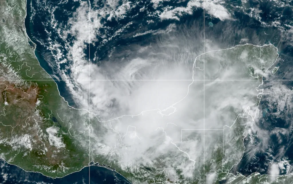
Tropical Storm Karl developed in the Bay of Campeche suddenly Tuesday. Now it’s closing in on southern Mexico, bringing the risk of gusty winds and heavy rainfall.
Tropical storm warnings are in effect from Coatzacoalcos to Sabancuy along the bay, where tropical storm conditions are probable in the next 24 to 36 hours. Karl’s slow speed thus far has made predicting its eventual track and impacts a challenge. While it has probably plateaued in intensity and won’t be a big windmaker, heavy rain could cause flooding in the Mexican states of Veracruz, Tabasco, Chiapas and Oaxaca.
Karl is the 11th named storm of the 2022 Atlantic hurricane season. Despite a busy month-long spate punctuated by multiple Category 4 storms, the season got a slow start. August passed without a named storm, the first time since 1997 that’s happened.
Meteorologists refer to a value called ACE, or accumulated cyclone energy, to gauge how active a season is. ACE is an integrated metric that takes into account storm intensity and duration.
A total of 83.7 ACE units have been churned through thus far, about 19.3 percent below average ― defying nearly unanimous predictions of an above-average season. Half of the ACE has stemmed from just two storms — Fiona, which blasted Puerto Rico before slamming the Canadian Maritimes, and Ian, which made landfall as a high-end Category 4 and killed more than 100 in southwest Florida.
As of 11 a.m. Eastern time Friday, Karl was inching ever closer to the coastline. It was nestled within the Bay of Campeche and was drifting southeast at 6 mph. Maximum sustained winds were estimated at 45 mph deep within Karl’s core.
The storm was about 80 miles northwest of Ciudad del Carmen, Mexico. Its outer rain bands were beginning to drench western portions of the Yucatán Peninsula and the gulf coast of adjacent southern Mexico.
On infrared satellite, it’s apparent that Karl is essentially one large mass of thunderstorms. In the middle, a few specks of purple and black can be seen, indicating extremely cold clouds. That represents the tallest clouds and highest tops. Meteorologists refer to the bubblelike parent updraft as an “overshooting top,” since the thunderstorms’ updrafts are so strong that they poke into the lower stratosphere before subsiding. It’s a sign that air is moving quickly upward.
On the storm’s periphery, hairlike tendrils radiate out from the clumping of thunderstorms. That’s an indicator of healthy outflow, or exhaust air at high altitudes exiting the storm and facing away from it. The more air a storm evacuates from above, the more its air pressure can plummet and the more warm, humid air it can ingest from below to fuel itself.
The limiting factor with Karl isn’t that sea surface temperatures aren’t warm enough; in fact, the Bay of Campeche is replete with oceanic heat content to support intensifying storms. Instead, wind shear, or a disruptive change of wind speed and/or direction with height, is conspiring to knock the storm off-kilter.
As a result, Karl won’t be strengthening markedly. Dry air is also wrapping around Karl and working to limit its intensity. As such, it may gain a little more oomph but should come ashore as a relatively modest tropical storm. The National Hurricane Center is predicting landfall near or just east of Paraíso, a town of nearly 100,000 people, Friday night into early Saturday.
Winds along the immediate coastline near the center may gust over 45 mph, accompanying a bit of coastal splash and rip currents. The bigger threat will be copious rainfall. Through Sunday morning, Karl is expected to drop a widespread 2 to 5 inches with localized 10-inch totals in Veracruz, Tabasco and northern Chiapas and Oaxaca.
“These rains could produce flash flooding, along with mudslides, in higher terrain,” the National Hurricane Center wrote.
Aside from Karl, the Hurricane Center is also monitoring a weak disturbance south of the Cabo Verde Islands, but it’s unlikely to develop.


