Skip to content
On the Weather

On the Weather

The Natural World in Beauty and Chaos

  • Home
  • About OTW
  • Privacy Policy
  • OTW Affiliates
  • Contact
Weather Blog
  • Home
  • All Regions
  • Weather Blog
  • Fire’s Footprint on Santa Rosa Island
  • Weather Blog

Fire’s Footprint on Santa Rosa Island

Fire’s Footprint on Santa Rosa Island
  1. Science
  2. Earth Observatory
  3. Fire’s Footprint on Santa…
  • Earth
  • Earth Observatory
  • Image of the Day
  • EO Explorer
    • All Topics
    • Atmosphere
    • Land
    • Heat & Radiation
    • Life on Earth
    • Human Dimensions
    • Natural Events
    • Oceans
    • Remote Sensing Technology
    • Snow & Ice
    • Water
    • Collections
    • Global Maps
    • World of Change
    • Articles
    • Notes from the Field Blog
    • Earth Matters Blog
    • Blue Marble: Next Generation
    • EO Kids
    • Mission: Biomes
    • About Us
    • Subscribe
    • 🛜 RSS
    • Contact Us
  • Search


May 16, 2026
May 24, 2026

A false-color image of Santa Rosa Island from May 16, 2026, shows a dark-brown burned area toward the bottom-right. A thin, bright orange line runs along the burned area, indicating the active fire front.
NASA Earth Observatory / Lauren Dauphin

A false-color image of Santa Rosa Island from May 24, 2026, shows a reddish-brown burned area spanning the eastern third of the island.
NASA Earth Observatory / Lauren Dauphin

A false-color image of Santa Rosa Island from May 16, 2026, shows a dark-brown burned area toward the bottom-right. A thin, bright orange line runs along the burned area, indicating the active fire front.
NASA Earth Observatory / Lauren Dauphin
A false-color image of Santa Rosa Island from May 24, 2026, shows a reddish-brown burned area spanning the eastern third of the island.
NASA Earth Observatory / Lauren Dauphin

May 16, 2026

May 24, 2026


The burned area from a wildland fire on Santa Rosa Island in California’s Channel Islands National Park grows between May 16 (left) and May 24, 2026 (right), in these false-color images captured by the OLI (Operational Land Imager) on Landsat 9 and Landsat 8, respectively.

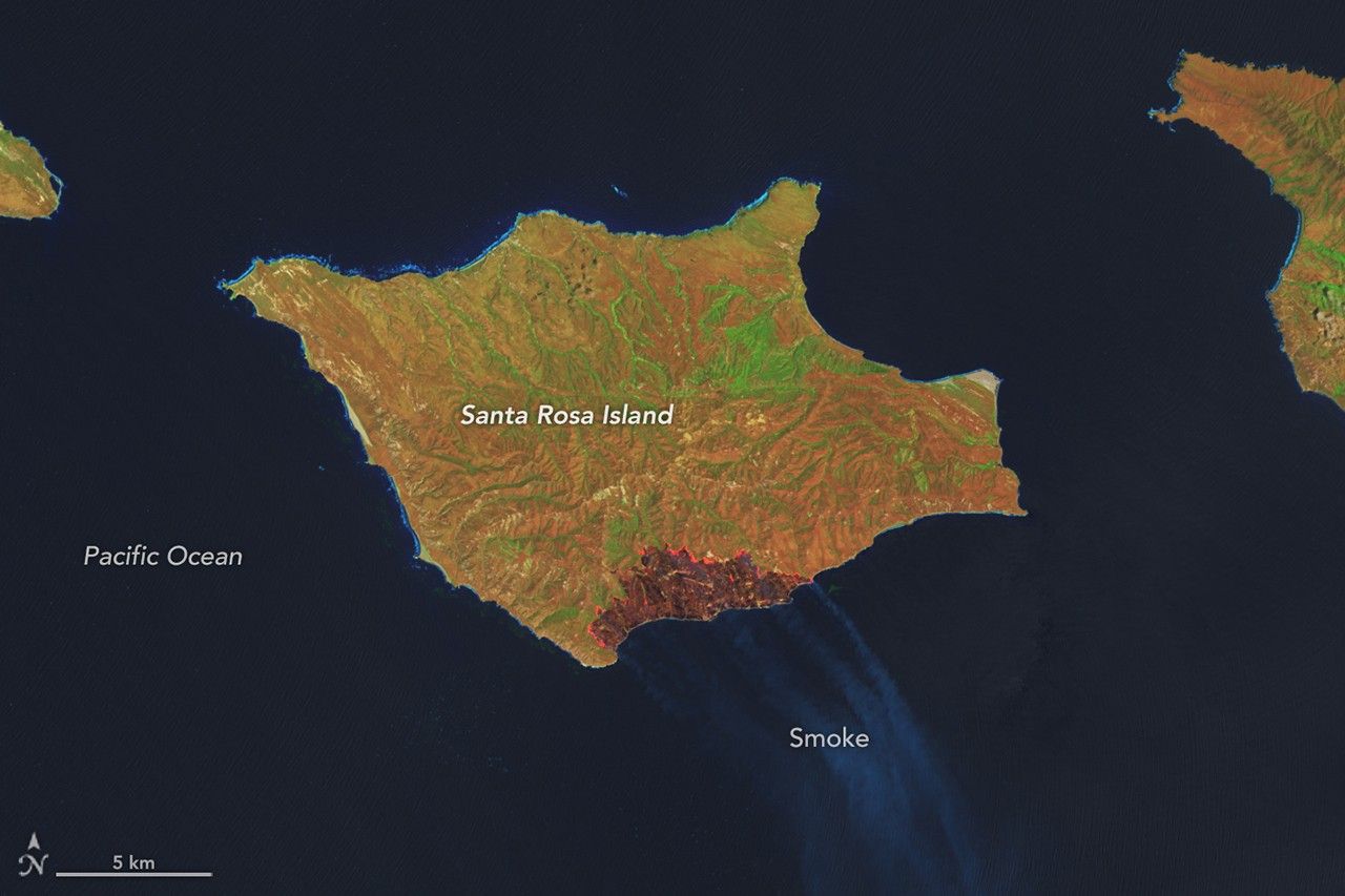
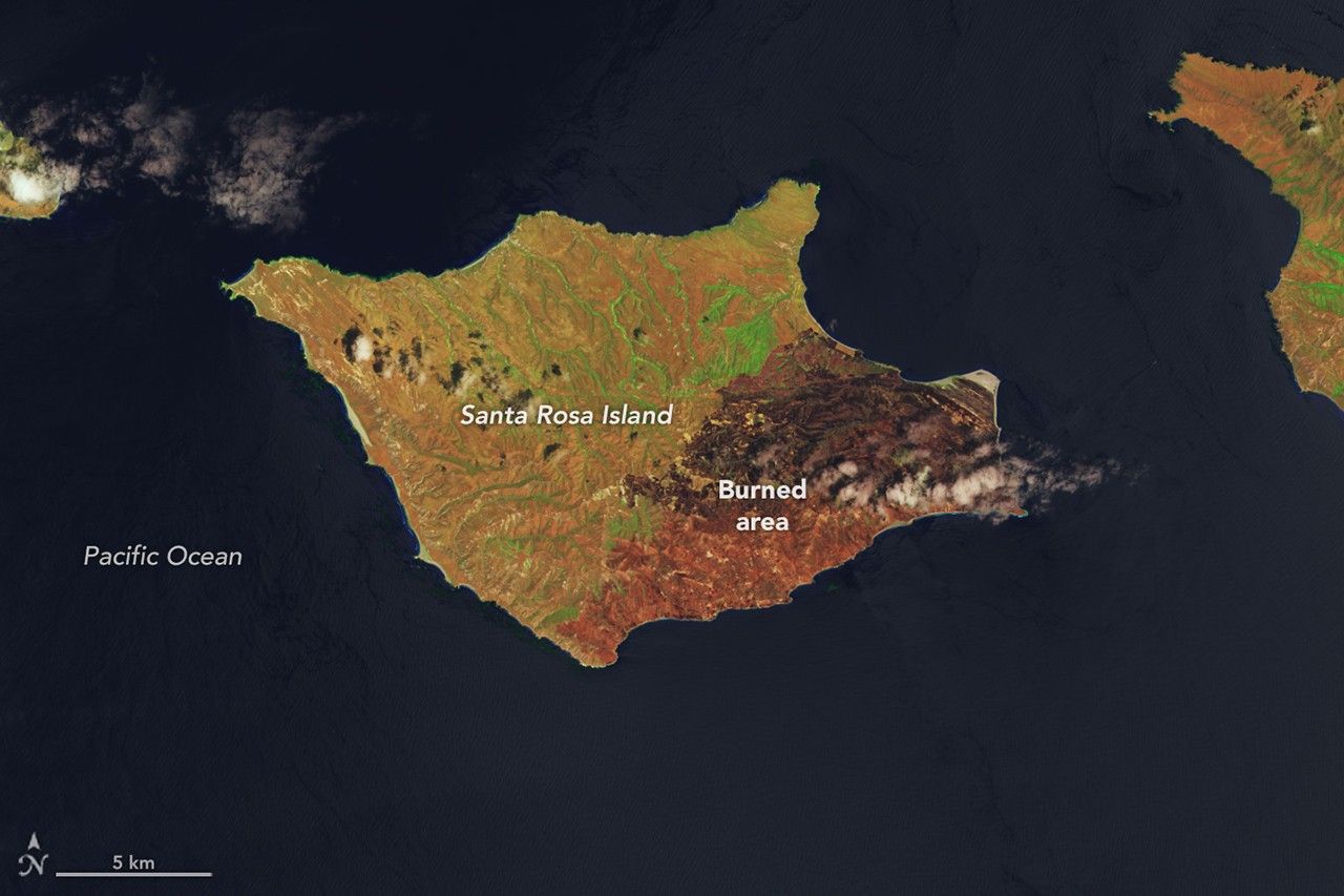
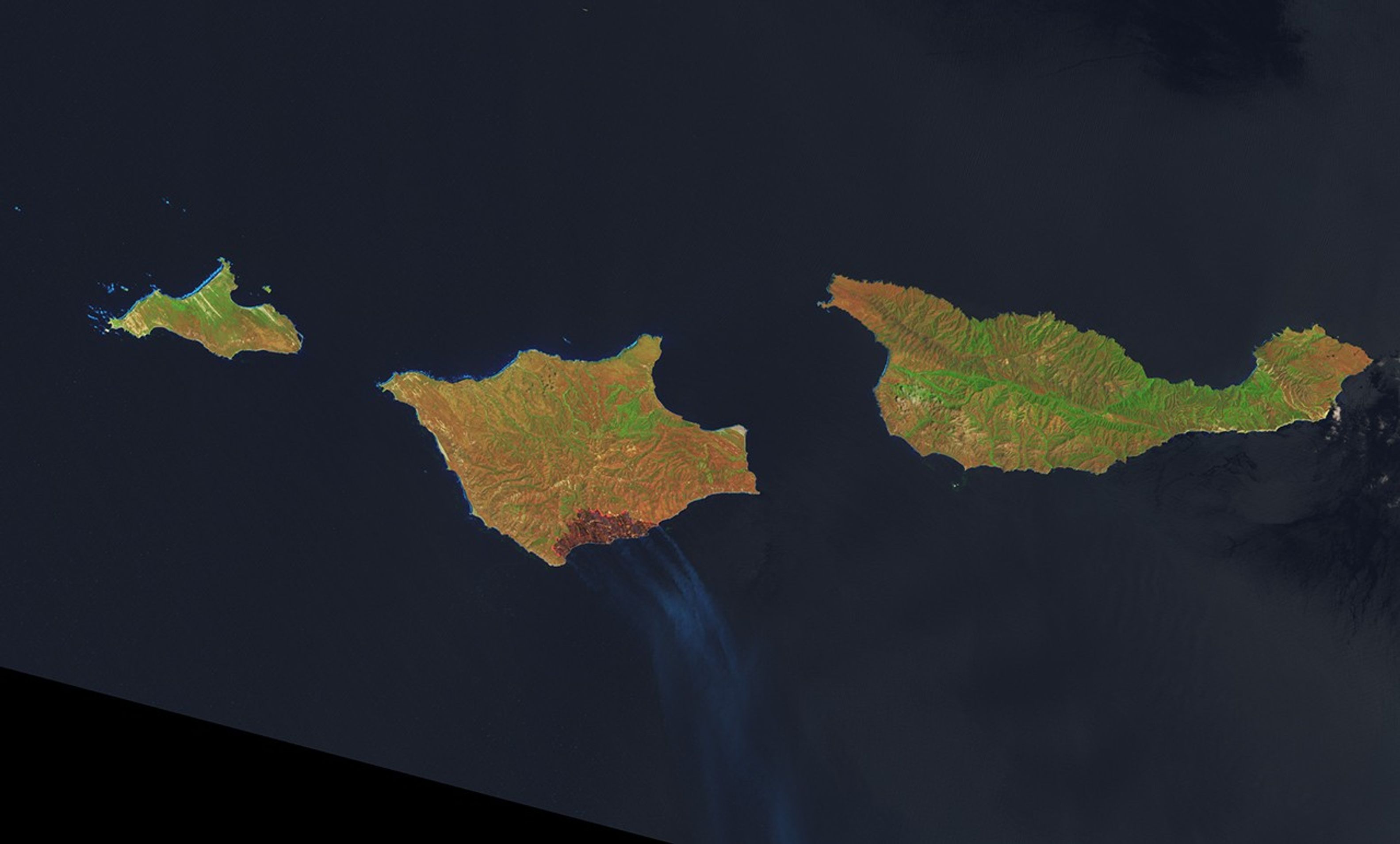
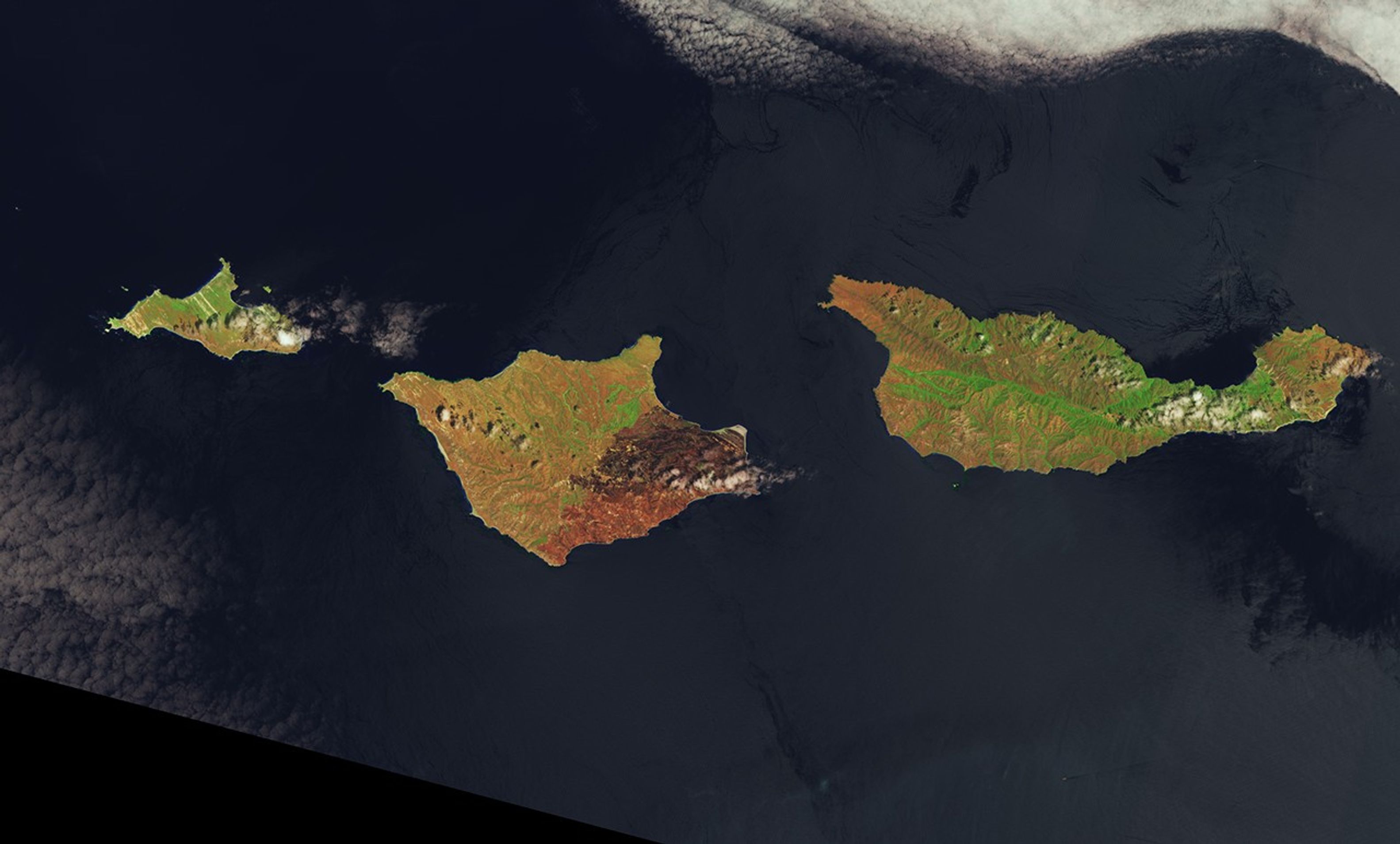
On May 15, 2026, a fire was spotted from aircraft on the southeastern side of Santa Rosa Island, part of California’s Channel Islands National Park. The blaze spread over the next several days, ultimately burning 18,379 acres (7,438 hectares)—about one-third of the island.

These images show the expansion of the fire’s burned area between May 16 (left), the day after it was discovered, and May 24 (right), after the fire’s growth had stabilized. The Landsat satellite images are false-color to help distinguish burned areas (brown) from healthy vegetation (green). Officials reported the fire was 97 percent contained by the evening of May 26.

NASA tools utilizing satellite observations, namely FIRMS (Fire Information for Resource Management System) and the Fire Event Explorer, show how the fire spread to the north and east over several days. As it advanced, it consumed areas of grassland, coastal sage scrub, and island chaparral.

Santa Rosa Island, like the other Channel Islands, is known for its diversity of plant and animal species, some of them rare. Observers were concerned that the fire threatened the island’s Torrey pines, a rare type of tree that in the United States grows naturally only on the northeastern coast of Santa Rosa Island and near San Diego.

Initial post-fire surveys by firefighters and unmanned aircraft indicated the Torrey pine stand remained largely intact. The fire mostly burned at lower intensity through the pine areas and spared the canopy. However, some pockets of forest sustained damage where intensity was higher. Along the northwest edge of the fire, suppression crews worked to protect another vulnerable area—the cloud forests—by cooling fuels ahead of the fire’s front.

Local reports suggest the Santa Rosa Island fire is the largest on record on any of California’s Channel Islands. Some of the islands’ chaparral and tree species are adapted to fire but less dependent on it than their mainland counterparts, according to the National Park Service, because naturally occurring fire is less frequent on the Channel Islands.

NASA Earth Observatory images by Lauren Dauphin, using Landsat data from the U.S. Geological Survey. Story by Lindsey Doermann.

Downloads

A false-color image of Santa Rosa Island from May 16, 2026, shows a dark-brown burned area toward the bottom-right. A thin, bright orange line runs along the burned area, indicating the active fire front.

May 16, 2026

JPEG (2.50 MB)

A false-color image of Santa Rosa Island from May 24, 2026, shows a reddish-brown burned area spanning the eastern third of the island.

May 24, 2026

JPEG (2.34 MB)

References & Resources

  • Capital Public Radio (2020) California Wildfire History Map. Accessed May 29, 2026.
  • InciWeb (2026, May 28) Santa Rosa Island Fire. Accessed May 29, 2026.
  • NASA Earth Observatory (2026, May 20) Fire Chars Santa Rosa Island. Accessed May 29, 2026.
  • National Park Service, Channel Islands. Accessed May 29, 2026.
  • Santa Barbara Independent (2026, May 21) What We’re Losing in the Santa Rosa Island Fire. Accessed May 29, 2026.

You may also be interested in:

Stay up-to-date with the latest content from NASA as we explore the universe and discover more about our home planet.

Fire Chars Santa Rosa Island

2 min read

The blaze spread across the southern side of the second-largest island in California’s Channel Islands National Park.

Article

Fires Tear Through Nebraska Grasslands

3 min read

Dry, warm, and windy conditions across the U.S. Great Plains led to extreme fire activity in March 2026.

Article

Smoke Rises Over Big Cypress National Preserve

2 min read

The National fire has burned tens of thousands of acres within the Florida preserve, fueled by vegetation dried by prolonged…

Article

1


2


3


4

Next
Keep Exploring

Discover More from NASA Earth Science

Subscribe to Earth Observatory Newsletters

Subscribe to the Earth Observatory and get the Earth in your inbox.


Earth Observatory Image of the Day

NASA’s Earth Observatory brings you the Earth, every day, with in-depth stories and stunning imagery.


Explore Earth Science


Earth Science Data

Open access to NASA’s archive of Earth science data

The post Fire’s Footprint on Santa Rosa Island appeared first on NASA Science.

​  

About Author

OTW Observer

See author's posts

Post navigation

Previous London thunderstorm dates after heatwave and when it will be sunny again

Related Stories

Gravity Waves From Super Typhoon Sinlaku Gravity Waves From Super Typhoon Sinlaku
  • Weather Blog

Gravity Waves From Super Typhoon Sinlaku

June 1, 2026
Painting the Growing Season in the Maize Triangle Painting the Growing Season in the Maize Triangle
  • Weather Blog

Painting the Growing Season in the Maize Triangle

May 29, 2026
A Shift in What’s Shaping U.S. Landscapes A Shift in What’s Shaping U.S. Landscapes
  • Weather Blog

A Shift in What’s Shaping U.S. Landscapes

May 28, 2026

Recent Posts

Recent Comments

No comments to show.

Archives

  • June 2026
  • May 2026
  • April 2026
  • March 2026
  • February 2026
  • January 2026
  • December 2025
  • November 2025
  • October 2025
  • September 2025
  • August 2025
  • July 2025
  • June 2025
  • May 2025
  • April 2025
  • March 2025
  • February 2025
  • January 2025
  • December 2024
  • November 2024
  • October 2024
  • September 2024
  • August 2024
  • July 2024
  • June 2024
  • May 2024
  • April 2024
  • March 2024
  • February 2024
  • January 2024
  • December 2023
  • November 2023
  • October 2023
  • September 2023
  • August 2023
  • July 2023
  • June 2023
  • May 2023
  • April 2023
  • March 2023
  • February 2023
  • January 2023
  • December 2022
  • November 2022
  • August 2021
  • February 2021
  • June 2020
  • December 2018

Categories

  • All Regions
  • Americas
  • Asia-Pacific
  • Atlantic
  • Caribbean
  • Europe
  • Oceania
  • South China Sea
  • Weather Blog

Weather Media Roundup

Fire’s Footprint on Santa Rosa Island Fire’s Footprint on Santa Rosa Island
  • Weather Blog

Fire’s Footprint on Santa Rosa Island

June 2, 2026
London thunderstorm dates after heatwave and when it will be sunny again London thunderstorm dates after heatwave and when it will be sunny again
  • All Regions
  • Europe

London thunderstorm dates after heatwave and when it will be sunny again

June 1, 2026
Gravity Waves From Super Typhoon Sinlaku Gravity Waves From Super Typhoon Sinlaku
  • Weather Blog

Gravity Waves From Super Typhoon Sinlaku

June 1, 2026
Painting the Growing Season in the Maize Triangle Painting the Growing Season in the Maize Triangle
  • Weather Blog

Painting the Growing Season in the Maize Triangle

May 29, 2026

OTW Hosting by Hostinger

Disclosure statement: Links to affiliate products are listed here. Ontheweather.com maybe compensated by displaying and promoting products seen here. Some of the products maybe of interest to you. Learn more about ontheweather.com privacy policy page.

Copyright © All rights reserved. OTW 2024 | DarkNews by AF themes.