


In mid-April 2026, Super Typhoon Sinlaku churned across the North Pacific Ocean and brought heavy rain and flooding to the Mariana Islands. The storm reached “violent typhoon” status—the highest intensity on the scale used by the Japan Meteorological Agency and roughly equivalent to a category 5 storm on the Saffir-Simpson wind scale. Sinlaku was one of only a handful of tropical cyclones of that intensity known to have occurred so early in the year in the region, meteorologists noted.
Sinlaku rapidly intensified over the ocean before its impacts reached land. Around the time of this strengthening, satellites began to detect that the typhoon’s effects also extended upward, into the upper atmosphere.
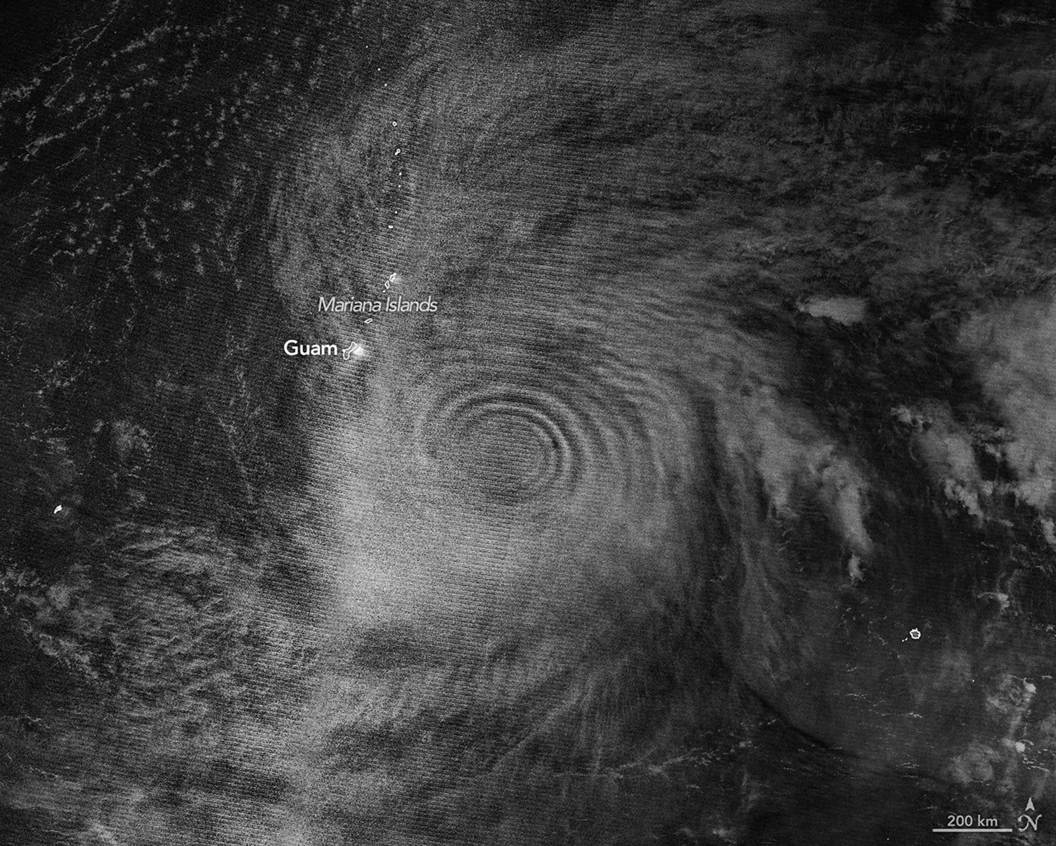
The nighttime image above, acquired with the VIIRS (Visible Infrared Imaging Radiometer Suite) on the NOAA-20 satellite, shows atmospheric gravity waves radiating from the typhoon. These waves, resembling ripples on a pond, were made visible to the sensor via airglow in the mesosphere. Airglow occurs when atoms and molecules, excited by sunlight during the day, later emit light to release excess energy.
The release of latent heat near the eyewalls of tropical cyclones is known to drive convection and the formation of tall cumulonimbus clouds. These “hot towers” can rise out of the troposphere, the lowest layer of the atmosphere, and generate waves that propagate into the stratosphere and mesosphere above. An analysis of past tropical cyclones revealed that gravity waves often occur around the time that storms are intensifying. Indeed, in the 24 hours prior to the acquisition of the image above, Sinlaku had strengthened from a category 2 to a category 5 storm.
“We’re seeing waves propagating radially and upward, in a cone-like shape,” said Joan Alexander, senior research scientist at NorthWest Research Associates. Alexander was surprised to see well-defined waves in the mesospheric airglow above the storm. Winds in the upper atmosphere can dissipate the waves before they reach such high altitudes, Alexander explained, but relatively light stratospheric winds at the storm’s latitude in April 2026 may have helped preserve them.
A relatively low amount of moonlight was fortuitous, as well. The VIIRS day-night band is sensitive to airglow in the mesosphere but also observes reflected moonlight. The Moon was about 25 percent illuminated on April 12, so some light reflected off clouds in the troposphere was visible, but not enough to overpower the signal from the airglow.
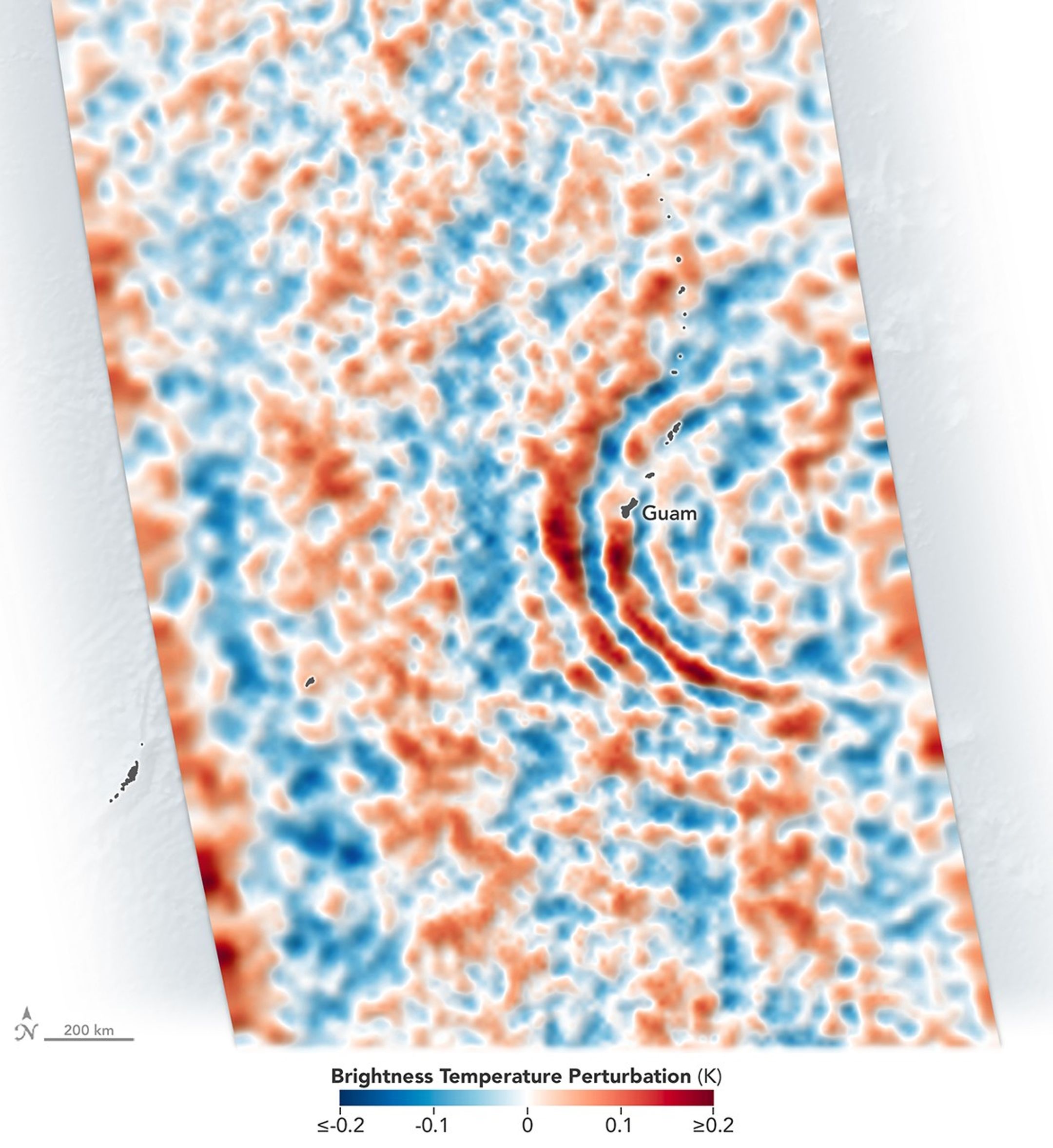
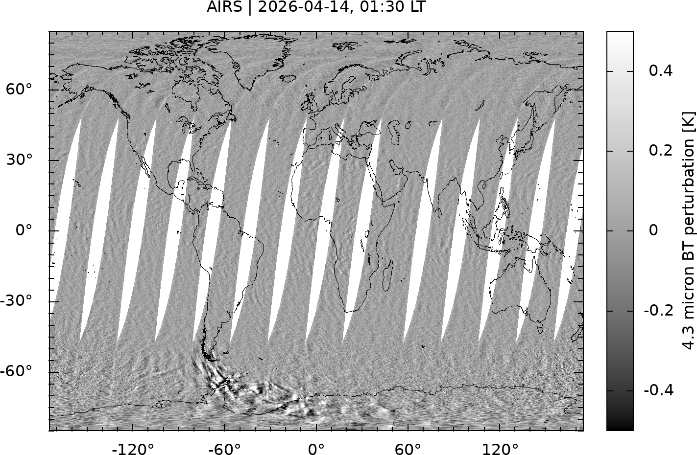
Sinlaku’s gravity waves, in addition to appearing high in the atmosphere via airglow, were observed lower in the atmosphere by the AIRS (Atmospheric Infrared Sounder) instrument on NASA’s Aqua satellite. The image above depicts thermal emissions from gravity waves in the stratosphere on April 13. The rippling pattern appeared in April 14 observations, as well, indicating the storm’s continuing effects on the atmosphere.
Observing atmospheric gravity waves, particularly those caused by tropical cyclones, goes beyond scientific curiosity. Practical implications could include improved monitoring of storm development. “We’d like to use gravity waves to tell us if a storm is intensifying,” Alexander said, “which can be difficult to know, especially over the open ocean.” A geostationary satellite with the proper infrared imager would be able to observe gravity waves and track tropical cyclone evolution, she and colleagues have argued.
Furthermore, it’s critical to account for processes in the stratosphere in weather models, said Laura Holt, also a senior research scientist at NorthWest Research Associates. Stratospheric wind patterns are factors in long-term forecasts of the next Northern Hemisphere winter, for example, and tropical cyclones have a disproportionate influence because their sustained, intense convection drives prolonged gravity wave forcing of the stratosphere.
The effect of gravity waves even reaches into the realm of space weather. “For a while, people have seen signatures of hurricanes in ionospheric weather,” Holt said. Gravity waves can lead to traveling ionospheric disturbances—large-scale ripples in plasma density—and in some cases plasma bubbles, both of which can disrupt satellite signals and radio communications. “With space weather in particular,” Holt added, “a single event such as a tropical cyclone can be very important.”
NASA Earth Observatory images by Michala Garrison, using VIIRS day-night band data from NASA EOSDIS LANCE, GIBS/Worldview, and the Joint Polar Satellite System (JPSS), and AIRS data from Hoffmann, L. Story by Lindsey Doermann.
References & Resources
Hoffmann, L., et al. (2018) Satellite observations of stratospheric gravity waves associated with the intensification of tropical cyclones. Geophysical Research Letters, 45, 1692–1700.
NASA (2018, October 22) Why NASA Watches Airglow, the Colors of the (Upper Atmospheric) Wind. Accessed May 28, 2026.
NASA Earth Observatory (2026, April 14) Super Typhoon Sinlaku. Accessed May 28, 2026.
Nolan, D. S. (2020) An Investigation of Spiral Gravity Waves Radiating from Tropical Cyclones Using a Linear, Nonhydrostatic Model. Journal of the Atmospheric Sciences, 77, 1733–1759.
You may also be interested in:
Stay up-to-date with the latest content from NASA as we explore the universe and discover more about our home planet.

The violent storm aimed at the U.S. Northern Mariana Islands and Guam in mid-April 2026.

The powerful storm lashed the northern edge of the continent with damaging winds and drenching rain as it made landfall…

Widespread flooding affected tens of thousands of people after cyclones Fytia and Gezani drenched the island.


The post Gravity Waves From Super Typhoon Sinlaku appeared first on NASA Science.


