Skip to content
On the Weather

On the Weather

The Natural World in Beauty and Chaos

  • Home
  • About OTW
  • Privacy Policy
  • OTW Affiliates
  • Contact
Weather Blog
  • Home
  • All Regions
  • Weather Blog
  • Chesapeake Bay Locked in Ice
  • Weather Blog

Chesapeake Bay Locked in Ice

Chesapeake Bay Locked in Ice
  1. Science
  2. Earth Observatory
  3. Chesapeake Bay Locked in Ice
  • Earth
  • Earth Observatory
  • Image of the Day
  • EO Explorer
    • All Topics
    • Atmosphere
    • Land
    • Heat & Radiation
    • Life on Earth
    • Human Dimensions
    • Natural Events
    • Oceans
    • Remote Sensing Technology
    • Snow & Ice
    • Water
    • Collections
    • Global Maps
    • World of Change
    • Articles
    • Notes from the Field Blog
    • Earth Matters Blog
    • Blue Marble: Next Generation
    • EO Kids
    • Mission: Biomes
    • About Us
    • Subscribe
    • 🛜 RSS
    • Contact Us
  • Search
 
A false-color satellite image of the Chesapeake Bay region shows the bay and its tributaries largely frozen, with the thickest blue and white ice concentrated along the eastern shoreline.
February 7-8, 1977

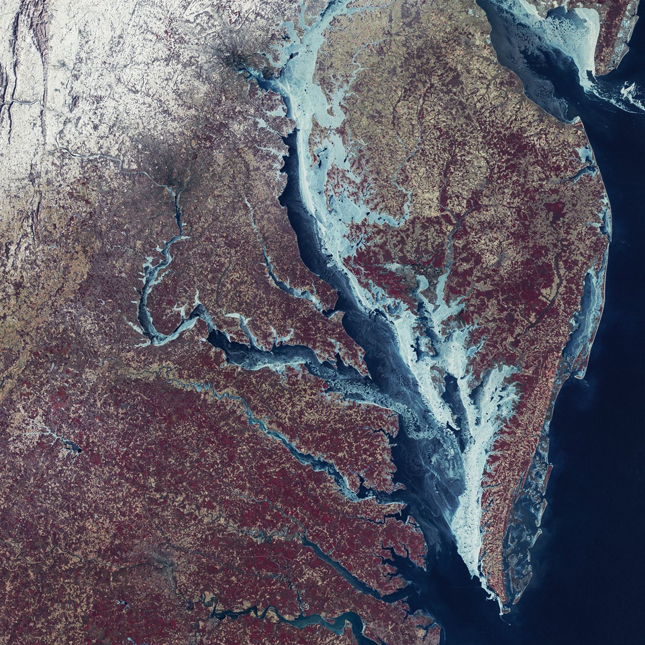
Residents of the U.S. Mid-Atlantic endured a formidable winter in 2025-2026, marked by several high-impact storms and prolonged stretches of cold temperatures that left parts of the Chesapeake Bay frozen over. Longtime residents may recall a winter nearly 50 years ago when the region saw even more widespread ice cover. 

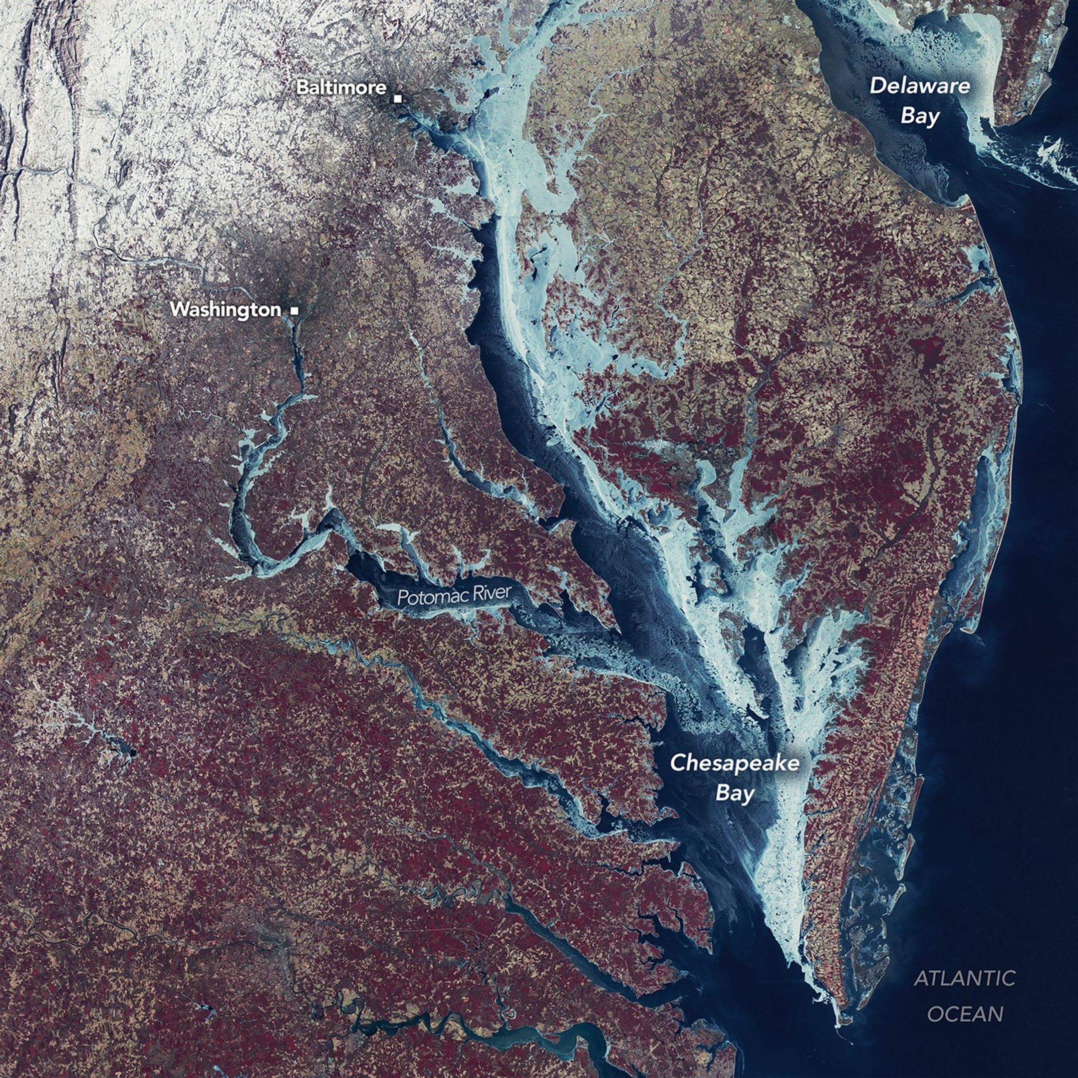
The MSS (Multispectral Scanner System) on Landsat 1 captured this image during the exceptionally cold winter of 1976-1977. The mosaic combines two Landsat scenes acquired on February 7 with a third captured on February 8. The landscape is shown in false color (MSS bands 6-5-4), in which ice appears in shades of blue, green, and white. On land, snow appears white, vegetation is red, and urban areas take on brown-gray tones.

A NASA analysis published in 1980 drew on these and other Landsat images to examine the anomalous ice conditions. Images indicate that ice began forming in the Chesapeake Bay’s upper tributaries in late December 1976 and spread to the middle of the upper bay by mid-January 1977. It reached its maximum extent around the time of this image, one week into February, when ice spanned 85 percent of the bay.

Persistent westerly winds at the start of February pushed ice toward the eastern shores of the Chesapeake and Delaware bays, contributing to fractures visible across the ice’s surface. As winds subsided, calmer conditions allowed new ice to form in areas of previously open water, visible in the image as thinner, darker blue patches. Reports from icebreaking operations indicated ice thicknesses reached up to 30 centimeters (12 inches) in the upper bay and up to 20 centimeters (8 inches) in the lower bay, with some tributaries seeing twice that amount.

Articles describing the event often show photos of people ice skating off Kent Island in front of the Bay Bridge and people driving cars and tractors across the ice. But the deep freeze strained the region, too. The ice and cold water caused high mortality in the area’s shellfish. And the crushing weight of the ice shifting with the tides damaged numerous piers, marinas, and lighthouses.

In winter 2025-2026, ice on the Chesapeake and Delaware bays appeared less extensive, with U.S. National Ice Center ice charts showing around 38 percent coverage on February 9 and 10. Still, concentrations in the upper bay and its tributaries this season were substantial enough to allow uncommon winter activities, including ice boaters racing across the frozen Claiborne Cove of Maryland’s Eastern Shore. At the same time, it created challenges for local watermen, according to news reports, trapping boats and limiting access to the bay.  

NASA Earth Observatory image by Mike Taylor, Ginger Butcher, and Michala Garrison, using Landsat data from the U.S. Geological Survey. Story by Kathryn Hansen.

Downloads

A false-color satellite image of the Chesapeake Bay region shows the bay and its tributaries largely frozen, with the thickest blue and white ice concentrated along the eastern shoreline.

February 7-8, 1977

JPEG (6.56 MB)

References & Resources

  • CBS News (2026, February 9) Frozen Chesapeake Bay leaves Maryland watermen struggling during peak oyster season. Accessed February 26, 2026.
  • Chesapeake Bay Magazine (2025, January 16) Ice Heroes: A Maryland Pilot’s Firsthand Account of the Historic 1977 Bay Freeze. Accessed February 26, 2026.
  • Foster, J. L. (1980, March) Ice Conditions on the Chesapeake s Bay as Observes! from Landsat During the Winters of 1977, 1978 and 1979. NASA Technical Memorandum, 80657.
  • Library of Congress (2023, July 28) The World as Seen by ERTS-1. Accessed February 26, 2026.
  • NASA (2026, February 13) Landsat 1 Graphics Library. Accessed February 26, 2026.
  • NASA (2026, February 12) Sick of freezing temperatures? For ice boaters, they’ve been a bonanza. Accessed February 26, 2026.
  • Secrets of the Eastern Shore (2022, January 16) The Great Eastern Shore Deep Freeze of 1976-77! Accessed February 26, 2026.
  • U.S. National Ice Center (2026, February 26) Mid-Atlantic Ice Chart. Accessed February 26, 2026.

You may also be interested in:

Stay up-to-date with the latest content from NASA as we explore the universe and discover more about our home planet.

Greenland Ice Sheet Gets a Refresh

3 min read

A moderately intense season of surface melting left part of the ice sheet dirty gray in summer 2025, but snowfall…

Article

Arctic Sea Ice Ties for 10th-Lowest on Record

3 min read

Satellite data show that Arctic sea ice likely reached its annual minimum extent on September 10, 2025.

Article

Antarctic Sea Ice Saw Its Third-Lowest Maximum

2 min read

Sea ice around the southernmost continent hit one of its lowest seasonal highs since the start of the satellite record.

Article

1


2


3


4

Next
Keep Exploring

Discover More from NASA Earth Science

Subscribe to Earth Observatory Newsletters

Subscribe to the Earth Observatory and get the Earth in your inbox.


Earth Observatory Image of the Day

NASA’s Earth Observatory brings you the Earth, every day, with in-depth stories and stunning imagery.


Explore Earth Science


Earth Science Data

The post Chesapeake Bay Locked in Ice appeared first on NASA Science.

​  

About Author

OTW Observer

See author's posts

Post navigation

Previous JPL 3D-Printed Part Springs Forward

Related Stories

JPL 3D-Printed Part Springs Forward JPL 3D-Printed Part Springs Forward
  • Weather Blog

JPL 3D-Printed Part Springs Forward

February 26, 2026
Dry-Season Floods Drench Northern Colombia Dry-Season Floods Drench Northern Colombia
  • Weather Blog

Dry-Season Floods Drench Northern Colombia

February 26, 2026
Landslide and Avalanche Debris Litter Hubbard Glacier Landslide and Avalanche Debris Litter Hubbard Glacier
  • Weather Blog

Landslide and Avalanche Debris Litter Hubbard Glacier

February 25, 2026

Recent Posts

Recent Comments

No comments to show.

Archives

  • February 2026
  • January 2026
  • December 2025
  • November 2025
  • October 2025
  • September 2025
  • August 2025
  • July 2025
  • June 2025
  • May 2025
  • April 2025
  • March 2025
  • February 2025
  • January 2025
  • December 2024
  • November 2024
  • October 2024
  • September 2024
  • August 2024
  • July 2024
  • June 2024
  • May 2024
  • April 2024
  • March 2024
  • February 2024
  • January 2024
  • December 2023
  • November 2023
  • October 2023
  • September 2023
  • August 2023
  • July 2023
  • June 2023
  • May 2023
  • April 2023
  • March 2023
  • February 2023
  • January 2023
  • December 2022
  • November 2022
  • August 2021
  • February 2021
  • June 2020
  • December 2018

Categories

  • All Regions
  • Americas
  • Asia-Pacific
  • Atlantic
  • Caribbean
  • Europe
  • Oceania
  • South China Sea
  • Weather Blog

Weather Media Roundup

Chesapeake Bay Locked in Ice Chesapeake Bay Locked in Ice
  • Weather Blog

Chesapeake Bay Locked in Ice

February 27, 2026
JPL 3D-Printed Part Springs Forward JPL 3D-Printed Part Springs Forward
  • Weather Blog

JPL 3D-Printed Part Springs Forward

February 26, 2026
Dry-Season Floods Drench Northern Colombia Dry-Season Floods Drench Northern Colombia
  • Weather Blog

Dry-Season Floods Drench Northern Colombia

February 26, 2026
Landslide and Avalanche Debris Litter Hubbard Glacier Landslide and Avalanche Debris Litter Hubbard Glacier
  • Weather Blog

Landslide and Avalanche Debris Litter Hubbard Glacier

February 25, 2026

OTW Hosting by Hostinger

Disclosure statement: Links to affiliate products are listed here. Ontheweather.com maybe compensated by displaying and promoting products seen here. Some of the products maybe of interest to you. Learn more about ontheweather.com privacy policy page.

Copyright © All rights reserved. OTW 2024 | DarkNews by AF themes.