Skip to content
On the Weather

On the Weather

The Natural World in Beauty and Chaos

  • Home
  • About OTW
  • Privacy Policy
  • OTW Affiliates
  • Contact
Weather Blog
  • Home
  • All Regions
  • Weather Blog
  • NISAR’s View of Mount Rainier
  • Weather Blog

NISAR’s View of Mount Rainier

NISAR’s View of Mount Rainier
2 Min Read

NISAR’s View of Mount Rainier

An overhead view of a mountain and the area around it, with unnatural colors added to the radar image. The ground is colored a bright spring green, while the mountain is purple, spreading out like a flower, with a center that's bright fluorescent yellow-green.
PIA26672
Credits:
NASA/JPL-Caltech
  1. Science
  2. Photojournal
  3. NISAR’s View of Mount Rainier
  • Photojournal Home
  • Photojournal Search
  • Latest Content
  • Galleries
  • Feedback
  • RSS
  • About
 

Downloads

PIA26672-NISAR’s View of Mount Rainier

JPEG (2.05 MB)

Description

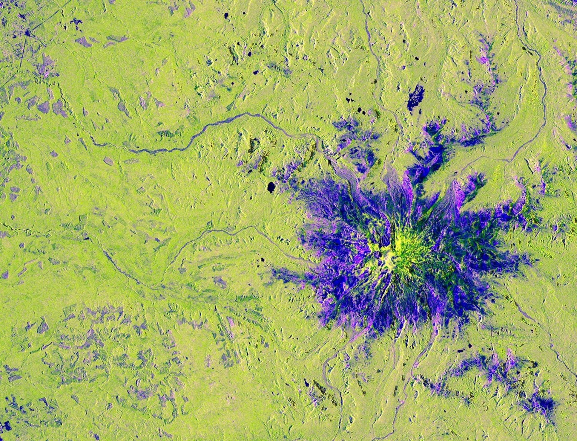
This image captured by U.S.-Indian Earth satellite NISAR on Nov. 10, 2025, shows Washington’s Mount Rainier. The image is cropped from a much larger swath spanning the Pacific Northwest on a cloudy day; NISAR’s L-band SAR instrument is able to peer through the clouds at the surface below.

In Pacific Northwest imagery from the NASA-ISRO Synthetic Aperture Radar mission, some areas are dotted in magenta due to radar signals strongly reflecting off flat surfaces like roads and buildings, combined with the orientation of those surfaces relative to the satellite’s ground track. The yellow can be produced by a range of different factors, including land cover, moisture, and surface geometry. Yellow-green in the imagery generally indicates vegetation, such as the forests and wetlands covering the region.

Relatively smooth surfaces, including water and — as is most likely the case in this image — vegetation-free clearings on the mountaintop, appear dark blue. Near the foot of the mountain are patches of purple squares cut into the lighter green vegetation. Their precise right angles show that they’re clearly man-made; they’re likely the effect of forests being thinned or possibly vegetation growing back after having been thinned in the past.

A joint mission developed by NASA and the Indian Space Research Organisation (ISRO), NISAR launched in July 2025 from Satish Dhawan Space Centre on India’s southeastern coast. Managed by Caltech, JPL leads the U.S. component of the project and provided the satellite’s L-band SAR and antenna reflector. ISRO provided NISAR’s spacecraft bus and its S-band SAR..)

The NISAR satellite is the first to carry two SAR instruments at different wavelengths and will monitor Earth’s land and ice surfaces twice every 12 days, collecting data using the spacecraft’s giant drum-shaped reflector, which measures 39 feet (12 meters) wide — the largest radar antenna reflector NASA has ever sent into space. 

To learn more about NISAR, visit:

https://science.nasa.gov/mission/nisar/

Keep Exploring

Discover More Topics From Photojournal

Photojournal


Search Photojournal


Photojournal’s Latest Content


Feedback

Downloads

PIA26672-NISAR’s View of Mount Rainier

JPEG (2.05 MB)

The post NISAR’s View of Mount Rainier appeared first on NASA Science.

​  

About Author

OTW Observer

See author's posts

Post navigation

Previous NISAR Views Mount St. Helens
Next Exact date thunderstorms will roll over London amid 5-day rain forecast

Related Stories

Spring Rains Saturate Michigan Spring Rains Saturate Michigan
  • Weather Blog

Spring Rains Saturate Michigan

April 17, 2026
Eyeing the Richat Structure Eyeing the Richat Structure
  • Weather Blog

Eyeing the Richat Structure

April 16, 2026
NASA’s SPHEREx Mission Maps Water Ice Throughout Cygnus X NASA’s SPHEREx Mission Maps Water Ice Throughout Cygnus X
  • Weather Blog

NASA’s SPHEREx Mission Maps Water Ice Throughout Cygnus X

April 15, 2026

Recent Posts

Recent Comments

No comments to show.

Archives

  • April 2026
  • March 2026
  • February 2026
  • January 2026
  • December 2025
  • November 2025
  • October 2025
  • September 2025
  • August 2025
  • July 2025
  • June 2025
  • May 2025
  • April 2025
  • March 2025
  • February 2025
  • January 2025
  • December 2024
  • November 2024
  • October 2024
  • September 2024
  • August 2024
  • July 2024
  • June 2024
  • May 2024
  • April 2024
  • March 2024
  • February 2024
  • January 2024
  • December 2023
  • November 2023
  • October 2023
  • September 2023
  • August 2023
  • July 2023
  • June 2023
  • May 2023
  • April 2023
  • March 2023
  • February 2023
  • January 2023
  • December 2022
  • November 2022
  • August 2021
  • February 2021
  • June 2020
  • December 2018

Categories

  • All Regions
  • Americas
  • Asia-Pacific
  • Atlantic
  • Caribbean
  • Europe
  • Oceania
  • South China Sea
  • Weather Blog

Weather Media Roundup

Lyrid meteor shower 2026 best time and chances to see in London Lyrid meteor shower 2026 best time and chances to see in London
  • All Regions
  • Europe

Lyrid meteor shower 2026 best time and chances to see in London

April 17, 2026
Exact dates London will bask in 5 days of sunshine in April Exact dates London will bask in 5 days of sunshine in April
  • All Regions
  • Europe

Exact dates London will bask in 5 days of sunshine in April

April 17, 2026
Spring Rains Saturate Michigan Spring Rains Saturate Michigan
  • Weather Blog

Spring Rains Saturate Michigan

April 17, 2026
Messy Weather Coming with Multiple Problems… Messy Weather Coming with Multiple Problems...
  • Caribbean

Messy Weather Coming with Multiple Problems…

April 16, 2026

OTW Hosting by Hostinger

Disclosure statement: Links to affiliate products are listed here. Ontheweather.com maybe compensated by displaying and promoting products seen here. Some of the products maybe of interest to you. Learn more about ontheweather.com privacy policy page.

Copyright © All rights reserved. OTW 2024 | DarkNews by AF themes.